This page contains explanatory notes and background information on various entries on the Books and Maps pages.
Click on any Books or Maps button to view the related entry on that page.

William Singer Barclay

The author was not above bending—and sometimes breaking—the truth to suit his purposes. On pp. 208-09 he has the following to say about Dr. Frederick Cook:
During the “Belgica” expedition, Cook stayed comfortably at Harburton [sic, Harberton] while the rest of the ship's company went south, picking him up on their return.
In fact, Cook went to Antarctica with the Belgica and was credited by Roald Amundsen and other crew members with saving their lives when the ship became trapped in the ice. He did indeed visit Harberton before and after Antarctica, but certainly did not stay there while the others went south. As a close friend of the Bridges family, Barclay presumably knew very well the actual facts of the matter. Cook's former friend and later rival the explorer Robert E. Peary, the New York Times and others launched a smear campaign against Cook, and it's tempting to surmise that Barclay lied about the facts as part of that campaign.
Nora Barlow
Lady Nora Barlow edited Charles Darwin's autobiography and restored passages that had been deleted by Sir Francis Darwin.
João de Barros
The author's Terceira Década da Ásia, dos feitos que os portugueses fizeram no descobrimento dos mares e terras do Oriente was the third of his four volumes, to which Diogo de Couto subsequently added nine more. When the set was reprinted (1778-1788), the title was revised to Da Ásia de João de Barros … Decada Terceira, Parte Primeira. This volume is included here because it contains Magellan's “Order of the Day.” An English translation is in Stanley: The First Voyage … .
William John Broderip
The unsigned review is attributed (without explanation) to William John Broderip (1789-1859) on the Darwin Online website. In Charles Darwin: A Companion, R. B. Freeman's entry for Broderip identifies him as a:
Barrister & conchologist …[who]…assisted Phillip Parker King in description of Molluses [sic, Mollusca] & cirripedes from 2nd voyage of Beagle, printed … in Vol. III of Narrative, 545-556, 1839.
The work (“ Description of the Cirrhipeda, Conchifera, and Mollusca …”) is actually found in Volume I at the indicated pages; it refers to the first voyage, and of course King was not present on the second voyage.
John Byron
Byron—dubbed “Foul-Weather Jack” because his voyages were so often marked by awful weather—was the grandfather of Lord George Anson Byron, the poet.
Gaspar Correa
According to Wikipedia, Correa lived ca. 1496-1563, and was in India from about 1512 until 1529. His eight-part Lendas da India (“Legends of India”), containing accounts of various Portuguese explorers, was first published some three centuries after his death, probably from his ca. 1550-1562 manuscript. See Stanley below for the English translation.
Publication date and partial list of explorers for each part are given in the list below.
- 1858: Tomo I: Vàsco de Gama, Cabral, Albuquerque, …
- 1859: Tomo I, Parte II
- 1860: Tomo II: Albuquerque, Soares, de Sequeira, …
- 1861: Tomo II, Parte II: (with account of Magellan voyage)
- 1862: Tomo III: Mascarenhas, de Sampayo, da Conha, …
- 1863: Tomo III, Parte II
- 1864: Tomo IV: de Noronha, Estevaō da Gama, de Sousa, …
- 1866: Tomo IV, Parte II
How Correa came to know of the Magellan voyage, which he includes in Tomo II, Parte II, is unknown. He had known Magellan in India before the expedition, and after returning to Portugal in 1529 may have spoken to surviving crew members. However, this part of his work is thought to have been written in about 1562, some forty years after the survivors reached Lisbon. The accounts may therefore have passed through several persons before reaching him, which may account from some of his errors, as noted by footnotes in the text.
Syms Covinton
The author was Fiddler & Boy to Poop Cabin when the Beagle began its voyage, became Darwin's servant in May, 1833, and remained in his service after the voyage. In his Journal, “Appendix A” is a list of Beagle crew members. However, the list is not the work of Covington himself, but was added later on, perhaps by someone at the University of Melbourne.
Juan de la Cruz Cano y Olmedilla, Sayer & Bennett, Schraembl

As noted on the Place Names page, the 1769 Cruz Cano y Olmedilla map is based on various relations, especialmente de las de Sarmiento, which explains the appearance on the chart of “C. de la Virgen Maria,” instead of Magellan's original “Cape of the 11,000 Virgins” as reported by Antonio Pigafetta. Later on, other cartographers used the chart as a source for their own work, but changed the cape name as in these two examples:
- 1775: Sayer & Bennett: Cape Virgins
- 1787: Schraembl: Cape Virgins (v. der Jungfrau Maria)
Both examples restore Magellan's “Virgins” (note plural) but omit the number. Perhaps to be on the safe side, Schraembl adds a parenthetical reference to the Virgin Mary. He also mis-spells “Olmedilla.”
All three charts are sequentially displayed via the link from each chart name, and the cartographer's name appears briefly at top center. The charts are followed by detail views of the cape area plus NASA satellite image for comparison, and then by the actual chart titles.
Charles Darwin
The 1905 Voyage of the Beagle text is presented here instead of the 1839 edition (vol. 3 of the FitzRoy el al Narrative …) or Darwin's 1845 second edition because it contains the revisions he made after the former two editions were published.
Notwithstanding a potentially-confusing title, the 1979 Journal of a Voyage … is a reproduction of Darwin's handwritten journal written while he was aboard the Beagle, and is therefore written in chronological order, as he went from place to place. He rearranged the content later on (that is, post-voyage), so that his coverage of places visited more than once would appear as a single entry in his subsequent Journal of Researches (1839 & 1845).
Lady Florence Caroline Douglas Dixie
The 1880 and 1881 books are the first English and American editions, respectively, and notwithstanding the first word of her book's title, Lady Dixie rode less then 200 miles of Patagonia's approximate 1,100 mile length. Julius Beerbohm's sketches have been re-drawn and signed by “C. W.,” “Ch. Wh (illegible)” [both, Charles Whymper] and “Pearson” [George Pearson]. The latter's name appears twice on the “We Were the First …” illustration. Some modern reprint editions give the title as Riding Across Pagagonia.
On October 29, 1880, Lady Florence wrote to Charles Darwin, referring to his remarks on the subterranean habits of the tucutuco, which Darwin believed, never comes to the surface of the ground. Lady Florence wrote:
I am sure it will be interesting to you to know that tho' this may be the usual habits of the tucutucu that there are exceptions.
Source: Darwin Project website: Lady Florence Dixie: a woman who had it all?
The full text of Lady Florence's letter is on the Darwin Correspondence Project website. In a subsequent letter she thanks Darwin for his reply, but his letter to her does not seem to be available (yet).
Marcel Destombes
The author's “The Chart of Magellan” is a description of a ca. 1522 untitled chart of the Southern Hemisphere by Pedro Reinel, believed to be a copy of his earlier chart which Magellan may have taken on his voyage.
In an Imago Mundi reprint presented to naval historian Samuel Eliot Morison, Destombes has corrected the chart legend with two hand-written insertions, shown here in italics:
Chart of the Antarctic Attributed to Pedro Reinel and containing original record of the voyage of Magellan in the Atlantic. M. D.
Sir Francis Drake
Although the “… by Sir Francis Drake” on the title page may suggest that this is the name of the author, it is actually part of the title. Drakes's nephew, also named Francis, signed the book's brief dedication to Robert, Earl of Warwick, and may or may not have edited the text, which is mostly taken from the journal of the ship's chaplain, Francis Fletcher. Note that Sir Francis died in 1596, some 32 years before the book was published in 1628.
Robert FitzRoy
FitzRoy's “Sketch …” was written shortly after the return of the Beagle from its second voyage. As the author notes on p. 337:
This sketch has been very hastily written, since the Beagle's arrival in England, and is therefore far inferior to the writer's wishes.
J. Gardner
In 1831, The Royal Geographical Society published J. Gardner's engraved Chart of a Part of South America, inserted between pages 156 & 156 in Phillip Parker King's “Some Observations …” paper. In 1839, the chart was inserted between pages 462 & 463 in Volume 1 of FitzRoy et al; Narrative of the Surveying Voyages … .
In both charts, San Sebastián bay is placed some 25 miles south of its actual location, and its inner shore deleted. The simple compass rose on the 1831 chart is omitted on the 1839 chart. The legends at the bottom of each chart are:
| 1831: |
Published for the Journal of the Royal Geographical Society by John Murray, Albemarle Street, London, September 1831. Lower Left: Printed by J. Shury; Lower Right: Engraved by J. Gardner |
| 1839: |
Published by Henry Colburn, Great Marlborough Street, 1839. Lower Left: blank; Lower Right: Engraved by J. Gardner |
Regarding the misplaced position noted above, one possible clue is a notation seen just to the right of the bay: “No opening was seen here by Capt. Fitzroy …” The notation first appears on the 1831 chart, thus suggesting that FitzRoy's observation was made on the first Beagle survey. If so, the chart may show an opening based on its presumed location, and the note points out that FitzRoy did not find it there.
On another Gardner chart—The Strait of Magalhaens—included in the 1839 edition only, Sebastián Bay is correctly placed and the notation is lacking, thus suggesting that FitzRoy did find the opening on the second Beagle voyage; the 1831 chart was not corrected, but the newer chart was created based on his later survey. In fact, his Table of Latitudes … gives accurate coordinates for locations on either side of the bay:
- North: Arenas Point
- South: Cape San Sebastian-northern height
The Cambridge University Library holds Charles Darwin's hand-colored copy of the chart, on which the presence of the simple compass rose and the Royal Geographical Society notation indicate his copy was from King's 1831 paper. Of particular interest is the San Sebastián area. A detail view shows that someone—perhaps Darwin himself—had “corrected” the chart, bringing it into agreement with Gardner's The Strait of Magalhaens chart mentioned above.
As far as is known, Darwin offers no explanation for the coloring he added to the chart. However, a “p. 94” notation on the back of the chart may be a clue that he wanted it inserted after that page—the final page of his Chapter IV—in the first edition of his Journal of Researches, perhaps when it was published separately from the FitzRoy et al multi-volume Narrative. If so, his wish was not realized, for reasons unknown.
Google Earth
This section will eventually provide links to various Google Earth 3D views of places not cited in texts offered on this website. To view place names cited in texts, click any icon (if any) within that text. For example, places cited by Darwin in his Voyage of the Beagle.
Richard Hakluyt
The work is included here because it includes “The Famous Voyage of Sir Francis Drake into the South Sea …” which in turn includes a description of Drake's arrival at San Julián, and attributes that name to Magellan. The “Famous Voyage” is printed on six unpaginated leaves, inserted between pages 643 and 644 of the book. See The Origin of San Julián for more details.
John Hawkesworth
Byron's “Journal” was heavily edited by Sir John Hawkesworth when he compiled several voyage accounts in his An Account of the Voyages … in 1773.
John Stevens Henslow
Henslow's “Description…” is included here because one of his illustrations is the source for the opuntia sketch in the 1890 illustrated edition of Darwin's Journal of Researches.
Kenneth E. Hill
Notwithstanding a bit of contradictory information in the front matter,§ The Hill Collection … is an excellent list and brief description of the volumes in the collection. It is presented here because so many of the voyages called at ports in Patagonia and Tierra del Fuego.
§ Foreword, p. ix: The second edition is “… a revised bibliography of the entire collection as it is in 2003.”
Publisher's Note, p. xxi. “The publishers wish to state clearly and emphatically that this is a catalogue of a collection, and NOT a bibliography.” [uppercase emphasis in original]
Alexander von Humboldt
Although the author's Personal Narrative has little or nothing to do with Patagonia and Tierra del Fuego, it is presented here since Darwin makes many references to it.
Michael Kerney
For reasons unknown, translator Michael Kerney is identified on the title page only by his initials.
Philip Gidley King, Phillip Parker King
Philip Gidley King § named his son Phillip Parker in honor of the first governor of New South Wales, Arthur Phillip, and Captain Thomas Parker, HMS Duke of Kent. Phillip Parker King subsequently named his own son Philip Gidley, in honor of his father. Hence the different spellings of the first name.
§ The elder King was the grandson of attorney-at-law John Gidley, hence his middle name.
Architect Richard Morris Hunt gave the globe to James Lenox, and it subsequently became part of the New York Public Library's collection of maps and globes. In Benjamin Franklin de Costa's “The Lenox Globe” article, a fold-out map shows the surface of the globe, which is considerably easier to study than the globe itself, which the author dates to ca. 1510-11. The drawing makes it clear that a large body of water below South America (shown in grey here) was known to exist more than a decade before the voyage of Magellan.
M. C. M. Leslie
Leslie was apparently associated with the Patagonian Mission Society, and assembled his Providence … from that Society's 1854 and 1856 The Voice of Pity publications, with insertions from other sources. (The 1856 edition of Voice … has not yet been located.) His given names (M. C. M.) are unknown. Despite its tedious “Bible thumping,” content, Leslie's work is presented here to illustrate how Robert FitzRoy and those who came after were viewed by at least some parts of the 19th-century religious community.
John Macdouall
The author, a Royal Navy officer, § was on HMS Beagle for the first 19 months of its first voyage to Tierra del Fuego under the command of Pringle Stokes. In August, 1827, he left the ship at Montevideo and returned to England; thus, he was not onboard when Stokes committed suicide.
§ While Macdouall makes no mention of his rank, FitzRoy lists him as Clerk in Volume I of the Narrative.
Perhaps the most interesting parts of his book are brief mentions of kidnappings and desertions—neither mentioned by anyone else on the voyage:
p. 271: “The grog shops were full of … English sailors … who had been detained when on shore leave, made drunk, and afterwards kidnapped on board some of the Brazilian men-of-war: the Beagle lost a number of men in this manner.”
pp. 298-99: “Early in the morning of our departure from [Ilha Cotinga, Brazil], we missed from the ship a marine § and a second class boy, and our steward …. Every search was made for these stragglers … but without success, and we were obliged to sail without them.”
§ The desertion of a Marine is indirectly contradicted by FitzRoy, who lists a “Sergeant and nine Marines” aboard the Beagle at both the beginning (p. xii) and end (p. xv) of the voyage. However, Pringle Stokes notes the “death of Serjeant Lindsey, of the Royal Marines” a few weeks before he took his own life. Therefore, if FitzRoy's listings are both correct, perhaps replacements were found, but not recorded, for the deceased Lindsey and the unidentified Marine deserter.
See the H. M. S. Beagle Crewlist page for an unsubstantiated claim of desertions on the second voyage.
Clements E. Markham
In his introduction to the Hakluyt Society's Early Voyages …, editor Clements Markham notes (pp. 14-15) that after the return of Magellan's Victoria, the uncertainty about the fate of the Trinidad and the crewmen left at Tidore, “It was finally resolved to send another expedition to the Spice Islands, by way of the new strait.”
The account of this expedition contains 53 numbered “Instructions to the Comendador Loaysa” (pp. 31-38), two of which are reproduced here:
VI. The Captain General is not to adopt a course, or to take a new direction without first calling a Council meeting consisting of all the captains, pilots and masters of the fleet.
XIV. If unable to double the Cape of Good Hope (Que no pudiendo doblar el cabo de Buena Esperança … in original), or, having doubled it, the bad weather prevents a continuance of the voyage, so as to make it advisable to find a port for winter, a Council shall be summoned to select the safest harbour.
In the original Spanish (Herrera, Década Tercera, p. 275), the instructions are un-numbered and contained within a single paragraph. And in context, it would appear that the fleet was expected to sail eastward to Maluca, not westward through the Strait of Magellan as stated in Markham's introduction. The Spanish excerpt in parentheses shows that “Cape of Good Hope” was not an error introduced in translation. However, the accounts of de Urdaneta and de Uriarte make it clear that the fleet sailed westward through the Strait of Magellan, and that there was no Council meeting to discuss a change of direction. Markham offers no explanation for this apparent change of plans.
H[arold]. E[dward]. L[eslie]. Mellersh
The author does not reveal the relationship (if any) between himself and HMS Beagle Midshipman (and later, Mate) Arthur Mellersh.
Mairin Mitchell
In his “Author's Foreword,” Mitchell comments on his subject's last name:
Over the correct form of Elcano's name, “de Elcano,” or “del cano” (sometimes “delcano”), controversy has been long and even impassioned. Those writers who adopt the latter form do so on the grounds that it is the one used by Juan Sebastian in signing both his will and his letter to the Emperor. [But] In 1873 the Geographical Society of Madrid stated that this form [“Elcano”] was the correct one.
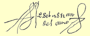
Keeping in mind the above sample of Juan Sebastián's signature, and that Navarette also refers to him as “Del Cano,” this form of his name is followed here.
Benjamin Morrell
The description of the author in The Hill Collection states (p. 413, 2nd edition) that “… Morrell has the reputation of drawing on his imagination at times and has been called the ‘biggest liar in the Pacific’.” The source of this anecdote is unknown, but it may have originated—with subsequent “improvements”— in a comment by Hubert Howe Bancroft in his 1886 History of California:
Morrell's “… absurd description of his adventures on a hunting tour … leave no room to doubt that the valiant captain was a liar.”
George Chaworth Musters
Musters' middle name is taken from his paternal grandmother, Mary Anne Chaworth.
Lady Florence Dixie mentions him several times in her Across Patagonia. Orphaned in 1845 at the age of four, he was raised by his uncles Philip and Robert Nicholas Hamond. The latter served aboard HMS Beagle, 1832-1833.
The Nonsuch 2005 reprint edition omits the book's sub-title and also the list of topics at the head of each chapter in the 1871 edition.
For reasons unknown, Sir John's last name was—and still is—frequently spelled “Narborough” despite the fact that he signed himself “Narbrough” (see sample below). To add to the confusion, the title page of An Account of Several Late Voyages & Discoveries … also lists him as “Narborough” even though he is “Narbrough” in his Journal included in that volume.

The three known versions of his map are summarized here:
- ca. 1690, engraved by John Thornton, no dedication, online image at California's Huntington Digital Library.
- ca. 1694, engraved by J. Sturt, dedicated to Samuel Pepys, bound into Narbrough's Journal.
- ca. 1713, Same, dedicated to Robert Harley, Earl of Oxford and Mortimer.
Each cartouche shows his name as “Narbrough.”
Perhaps the next “Narborough” appearance (1699) was in “Cowley's Voyage Round the Globe” in William Hacke's Collection of Original Voyages:
(p. 10) And before the said Bay lieth another Island, the which I call'd Sir John Narborough's.
However, Herman Moll's map in the same book (facing p. 9) shows this island as “Narbrough Isl.”
Years later (1839), he is again “Narborough” in the accounts of Phillip Parker King, Robert FitzRoy and Charles Darwin.
The port of San Julián is correctly placed on the three maps cited above, but the text legend is correctly placed next to the actual port on version 1 only. This agrees with Narbrough's own reference to “The Mouth of Port Saint Julian, in Latitude 49 d. 10 m. South.” On versions 2 & 3, the text legend is displaced about 70 miles south of its actual location (at approximately 50° 20' S).
A note at the Huntington Digital Library site states that version 1 was dated ca. 1690 by (London book dealer Leon) Kashnor, but does not identify the source. Thought to be Kashnor's Americana: Rare and Valuable Books, Early Maps, Fine Engravings and Original Drawings.
The de Nodal brothers were the first to report the existence of the San Sebastián Channel, connecting the modern Bahías Inutil and San Sebastián. The first edition is dated 1721, and the second is undated. Although the Hakluyt edition inserts the year 1766 on the translated title page, “Año đ 1769” is in the lower right-hand corner of the map inserted between pages 72 & 73 of the latter edition, and that date is used here as the publication date. Map engravers are:
1721: I (Jean) de Courbes
1769: Manuel de Rueda
Note: “Viaje” in 1721, “Viage” in 1769 titles.
Antonio Pigafetta
The four known versions of Pigafetta's manuscript are summarized below, followed by a listing of a few printed editions.
| Pigafetta Manuscripts | ||
|---|---|---|
| Number | Location | Language |
| 24224 § | Paris: Bibliothèque Impérial | French |
| 5,650 | ||
| New Haven, CT: Beinecke Library, Yale University | ||
| L. 103 Sup. | Milan: Ambrosian Library (popularly called the “Ambrosian” ms.) | Italian |
| § The Hakluyt editor's Introduction assigns the number 68 to this ms. | ||
| Pigafetta Printed Editions | |||
|---|---|---|---|
| Year | Publisher | Title | Language |
| undated | Jacques Fabre | Le Voyage et Navigation, faict par les Espaignolz … | French |
| 1536 | unknown | (unknown title; translation of Fabre edition) | Italian |
| 1625 | Richard Wren | (unknown title) | English |
| 1800 | Amoretti | Primo viaggio intorno al globo terracqueo … dal caualiere Antonio Pigafetta. | Italian |
| 1801 | H. J. Jansen | (unknown title; translation of Amoretti edition) | French |
| 1906 | Arthur H. Clark | Magellan's Voyage Around the World | English & Italian |
| 1969 | Yale Univ. Press | Magellan's Voyage | English & French |
James Burney printed a segment of Pigafetta's account of the San Julián incident, but does not identify his source, which was the Ambrosian ms. (see above manuscript table). The English translation of that segment (below) in the Clark 1905 edition is identical to Burney's, which suggests the former was copied from the latter.
Those conspirators consisted of the overseer of the fleet, one Johan de Cartagena, the treasurer, Alouise de Mendosa, the accountant, Anthonio Cocha, and Gaspar de Cazada. The overseer of the men having been quartered, the treasurer was killed by dagger blows, for the treason was discovered. Some days after that, Gaspar de Casada, was banished with a priest in that land of Patagonia. The captain-general did not wish to have him killed, because the emperor, Don Carlo, had appointed him captain.
Burney adds a footnote to his version of the above:
What is said by Pigafetta of Gaspard de Casada, should have been related of Juan de Cartagena.
In other words, de Casada was executed, while Cartagena was banished with the priest, as correctly stated in the three French mss. The error rules out the possibility that the Milan ms. is the work of Pigafetta himself, who surely would not have made such a blunder when writing in his own native language. It would therefore seem to have been written by someone who got the facts mixed up. The Hakluyt editor (Stanley of Alderly) makes no mention of this error, although—given his numerous footnotes referring to variations found within the Milan ms.—he was presumably quite familiar with it.
Nor does he reveal which of the three French mss. he used for his translation.
In Popper's lecture at the Argentine Geographical Institute, he spoke of the former existence of the San Sebastián Channel. See In Search of San Sebastián for an excerpt from his presentation.
In Ramusio's three-volume Delle Navigationi et Viaggi, only the recto pages are numbered; in vol. I, pp. 1-394. The modern recto page is therefore twice the printed number minus 1, or minus 2 for the facing verso page.
Publication dates are:
vol. I: 1550
vol. II: 1559
vol. III: 1556
Ramusio's work is often referred to as the “Ramusio Collection” or “Ramusio's collection of voyages” (or similar) and its actual title is not given.
 Although for the most part an excellent survey of voyages to and through Cape Horn, every now and then the author lapses into a fictionalized account of events, as in his version of those events leading up to the second voyage of the Beagle (details to follow). The dust jackets and frontispiece (first edition only) show a painting by Gordon Grant (1875-1962) of Schouten's Unity, with Chilean Isla Navarino and Cape Horn colored as part of Argentina.

Pedro Sarmiento de Gamboa
Note that the title of the chart includes “imputada a [attributed to] Sarmiento de Gamboa [emphasis added]. Although it may indeed have been drawn by Sarmiento, there is some “evidence” that a later hand made some additions. For example, Sarmiento had re-named:
- Cape of the 11,000 Virgins to Cape of the Virgin Mary [Cabo de la Virgen María on his chart],
- The Strait of Magellan to the Strait of the Mother of God. (See commentary by James Burney on this change.)
The chart shows the former change, but not the latter. Since it is unlikely that Sarmiento himself would have written only one of these changes, it is assumed here that “Estrecho de Magallanes” was written by someone else.
Walther Schiller
The sketch map of Lieutenant Sholl's gravesite accompanies the author's “A Lonely Grave in Patagonia” paper (p. 76). It shows not only the grave location, but also Sir Francis Drake's “Island of True Justice” (Banco Justicia on the map—coloring of water added).
Schiller gives Philip Parker King's account of Sholl's death, then adds:
This account of Sholl's death disposes of the local tradition that he committed suicide after having run the Beagle aground (p. 75) [and] The impression that Sholl had committed suicide probably arose from confusion with the death [by suicide] of Commander Pringle Stokes (p.76).
Johannes Schöner
The editor of Monumenta Cartographica (Dr. Frederik Caspar Wieder, Librarian of the University of Leiden) has interpreted a “PERISCH” legend on one of the globe gores as follows:
“If this word is divided into three parts, we get the meaning of it: PER I SCH, the I indicating Joannes, the SCH Schöner, i. e. per I. Schöner— by Johannes Schöner.”
However, the legend is in fact “PERISCII”—a word to describe “Those who live within a polar circle, whose shadows, during some summer days, will move entirely round, falling toward every point of the compass.” (Webster's Revised Unabridged Dictionary). The word appears directly below the Antarctic circle on the globe gore. In The Mapping of the World, editor R. A. Skelton writes:
“The craftsman-artist could well be from the school of Schöner, … The gores are tentatively dated c. 1535; they could be earlier but are unlikely to be as early as 1523-24 as stated by Wieder.”
William Cornelison Schouten
The Wonderful Voyage is an English translation by “W. P.” (William Philip) of the original Dutch Journal ofte Beschryvinghe …. The identity of the actual author is unknown, but in referring to the passage named as the Strait of Le Maire, the author wrote (p. 25) that “ … by good right it should rather have been called William Schouten's Strait.” In a pamphlet accompanying the facsimile edition, A. L. Rousen concludes (p. 20) that the book “… was evidently written by one on the side of Schouten.”
The author states the latitude but makes no attempt to estimate the longitude in many of the ship positions. Accordingly, in preparing the ship route in Google Earth (on Maps page, or any globe icon within text), a straight line was drawn from one known location to the next such location (Tenerife to Cape Verde, for example; viewed via globe icons within the text). Then, the longitude of any point, or points, between these locations (in this example, the Tropic of Cancer) was noted in Google Earth and used to place an icon at that position.
Francisco Seixas y Lovera
In Titulo XXXI, Seixas describes la Canal de San Sebastian and states (folio 63) that “Desta Canal, aunque la hemos visto, no hemos estado en ella, y hemos sabido comunicando con algunos que la han Navegado en parte, que es fondable para embarcaciones de poco porte.” (“Of this canal, although we have seen it, we have not been in it, and we have reliable communications from others who have navigated it in part that it is fit for anchorage by vessels of small portage.”)
Lord Henry Edward John Stanley
The First Voyage Round the World Introduction states that “This volume contains six contemporary accounts of Magellan's voyage … ” but gives only the vaguest references to his sources. The quotations which follow are taken from Stanley's Introduction. Additional details will be added as soon as possible.
- The Genoese Pilot's Account of Magellan's Voyage
- “Of this account, three manuscripts exist. From two of these MSS, a printed edition [title not given] was published in the Noticias Ultramarinas, No. II, by the Academy of History in Lisbon.”
- The source for Stanley's claim that this is thought to be the account of the Genoese pilot Juan Bautista is unknown. The Magellan Fleet Timeline page on this website shows that, according to Navarette, Bautista was the master, not the pilot, of the Trinidad. (See footnote at end of table for details.)
- Narrative of the Anonymous Portuguese
- This account is “taken from Ramusio.” In Ramusio's Delle Navigationi et Viaggi (“Navigations and Travels”), vol I, p. 370.
- Pigafetta's Account of Magellan's Voyage
- See Pigafetta: Magellan's Voyage for one of the three French manuscripts known to exist.
- Magellan's Order of the Day in the Straits
- The title page states “taken from Barros, Decade III, liv. v, Cap. 19 [sic, IX, pp. 640-642].” See Barros for details about the title. Probably not counted as one the “six contemporary accounts” by Stanley.
- Letter of Maximilian, the Transylvan
- “This has been translated from the Latin… .” A Spanish version, Relacion escrita por Maximiliano Transilvano… is in Navarette, vol. 4, pp. 249-284.
- Log-Book of Francisco Alvo or Alvaro
- “This log-book has been printed, in Navarette's collection, apparently from the British Museum MS.” The ms. is not identified, and the printed version is presumably that in Navarette, vol. 4, pp. 209-247.
- Account of the Mutiny in Port St. Julian, and Gaspar Correa's Account of the Voyage
- The Account of the Mutiny is in Navarette, vol. 3, Appendix XX, pp. 189-201.
- The Hakluyt edition states that Correa's account is in his Lendas de India, tome [sic, tomo] II, cap. XIV. It is actually in Tomo II, Parte II, cap. XIV, pp. 625-634. See Correa for additional details about this work.
- See also the notes at the top of the Correa page for details about the Hakluyt Society edition.
Hernando de la Torre
de la Torre's “Derrotero del viage …” comprises Appendix XIV in Navarrete: Coleccion de los Viages y Descubrimientos …, volume 5. A footnote on the first page (p. 241) of the Appendix states:
“In this relation is found a derrotero of the complete voyage from la Coruña to the isles of Maluco, with a very particular description of the Strait of Magellan and of the same the Isles of Maluco, written by the pilot Martin de Uriarte.”
Turin Map
The map by an unknown cartographer is popularly known as the “Turin Map” after its location in the Royal Library of Turin, Italy (Biblioteca Reale di Torino). Among other place names, the map detail view shows:
- Rio de Santiago: This was (re-)named Rio Santa Cruz on the Magellan expedition, and so presumably pre-dates that expedition. It also suggests the Magellan crew were unaware of the earlier name.
- Baya de San Giuli_: Despite the unclear and missing letters, the first five letters are enough to indicate the name is Guilian (or Guiliano). See the San Julián page for more details about this name.
Martin de Uriarte
The expedition to Maluco, 1525-1536, is generally known as the “Loaysa Expedition” after Garcia Jofre de Loaysa, the commander of the expedition. The ships were: Anunciada, Pataje, San Gabriel, San Lesmes, Santa Maria de la Victoria, Santa Maria del Parrel and Santi Spiritus. Martin de Uriarte, the pilot of one of the ships, provided a fairly detailed description of the passage through the Strait of Magellan, as part of Hernando de la Torre's “Derrotero …” (see de la Torre, above). Neither he nor the Hakluyt Society editor name the ship but since he subsequently witnessed the last will of Sebastián del Cano onboard the Victoria, presumably he was pilot of that ship.
Johannes van Walbeek
van Walbeek's map shows “Windhonds Bay,” named after the Dutch Nassau Fleet ship Windhond [Dutch; Wind hond = greyhound] which visited the area during the first quarter of the 17th century. See “On the Locations ...” for details about Windhonds Bay on the southern coast of Tierra del Fuego.
Note: For reasons unknown, the bay's name is given in English instead of Dutch (“Wind Hond Baai”), and the English “Bay” appears at other locations on the map. Also, “Hoorn” is mis-spelled (“C. de Horen”), and the Spanish “Isla” rather than the Dutch “Eylandt” is abbreviated at “I. de Diego Ramires” [sic, Ramirez].
Martin Waldseemüller
Waldseemüller's map seems to favor Portugal over Spain. As noted by Peter Dickson (p. 28), “… there is no sign of the demarcation line established by the Treaty of Tordesillas … [and] … the placement of that little Portuguese flag near the southern end of what we know today as Argentina was quite brazen in legal terms.”
James Weddell

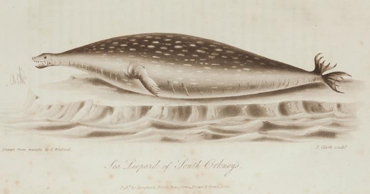
While at the Orkneys, Weddell encounterd a quadruped that he described as a “Sea Leopard” and subsequently sent his drawing of it (paint-can icon above) to the Edinburgh Museum. The animal was named “Weddell Seal” by the French naturalist René Primevère Lesson, and not by Weddell himself.
John Wood
Despite the “Captain” in the title, Wood was Master on the Sweepstakes and John Narbrough was the captain. Later (1676) Wood was made captain of the Speedwell frigate. By the time his “Voyage” was published almost 20 years later he'd held that rank for quite awhile, which may explain its appearance in his title.
Writing in The Threshold of the Unknown Region (London, 1873: Samson Low, et al, p. 42), author Clements Markham says the following of Wood:
On his return he published ‘Captain Wood's Voyage through the Streights of Magellan,’ in which Narborough's name is not once mentioned, and, for all that appears to the contrary, Wood was commanding the expedition.
It's true that Narbrough's name is not mentioned, but Wood makes some thirty references to “our Captain” (or similar), making it very clear to his readers (with the notable exception of Markham) that he was not the captain.