Ascension Island, 1831

Lewis Monto's coastal views of Ascension Island
(now Pohnpei), 1831.
[Click to enlarge image]
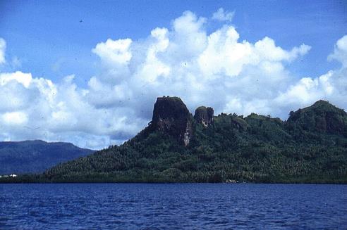
Contemporary photograph of Sokeh's Rock,
Pohnpei, Federated States of Micronesia.
[Click on image to view in a new window.]
Annotations:
"Ascension Island"
Top: "North Side Latt 7:02 N Long 158:15 East"
[showing: "reefs"]
Bottom: "South Side"
NOTES:
Lewis Monto's sketch of Ascension Island in 1831 was originally found in his manuscript journal of the 1828-1830 whaling cruise of the Nantucket whale ship, Plough Boy, Nathan Chase, commander. Monto was the ship's cooper on this voyage.
Ascension (Pouynipete, Panape, Pohnpei, etc.) had only been visited (and named) by Fyodor Litke of the Senyavin in January 1828. It most likely was not named on any chart carried by the Plough Boy in 1830-1834. J. W. Norie's "New Chart of the Pacific Ocean" did identify the island as Ascension in 1836.
Lewis Monto's latitude and longitude of "Latt 7:02 N Long 158:15 East" agree closely to the 6° 53'N & 158° 14'E given by Wikipedia.
The sketch is now in the collection of the Nantucket Historical Association on the island of Nantucket, Massachusetts.
Last updated by Tom Tyler, Denver, CO, USA, Dec 3 2021.
|

