Previous AnthologyList of ChartsSourceWhalesite Next

Title Page

LIST OF CHARTS


VOLUME II.

Phoenix Group (General Sheet), 56
Swain's Island, Jarvis's Island, Birnie's Island, Enderbury's Island, Hull's Island, and New York or Washington Island, 57
Union Group; Fakaafo or Bowditch Island, Nukunono or Duke of Clarence Island, and Oatafu or Duke of York Island, 58
Ellice's Group; Funafuti or Ellice's Island, Nukufetau or Depeyster's Island, 59
Bigini or Pescadores Island, and Radogala and Korsakoff Islands, 60
Hawaiian Group, or Sandwich Islands (General Sheet), 61
Part of the Island of Hawaii, Sandwich Islands, 62
Harbor of Waiakea, Island of Hawaii, 63
Gardner's or Kemin's Island, Flint's Island, McKean's Island, Maro Reef, and Lahaina Roads, Island of Maui, 64
Wahiawa Harbor, Waimea Bay, Hulaia Harbor, and Kaneohe Harbor 65
Harbor of Ewa or Pearl River; Harbor of Honolulu, 66
Oregon Territory, 67
Mouth of Columbia River. Sheet 1, , 68
Columbia River Sheet 2, 69
Columbia River Sheet 3, 70
Columbia River Sheet 4, 71
Columbia River Sheet 5, 72
Columbia River Sheet 6, 73
Columbia River Sheet 7; Willamette River and Wapauto Branch, 74
Gray's Harbor, 75
Straits of Juan de Fuca, 76
Archipelago of Arro, Gulf of Georgia, Ringgold's Channel, and Fraser's River, 77
Admiralty Inlet, Puget Sound, and Hood's Canal, 78
Inlets in Puget Sound, 79
St_ Juan and Scarborough Harbors, and Port Discovery, 80
New Dungeness Roads and Budd's Harbor, 81
Ports Townsend and Lawrence, 82
Ports Ludlow and Gamble, 83
Colsee-ed and Suquamish Harbors, 84
Hooetzen and Scabock Harbors, and Tzu-sa-ted Cove, 85
Case's and Carr's Inlets, 86
The Narrows and Commencement Bay, 87
Ports Orchard and Madison, 88
Apple and Pilot Coves, and Ports Gardner and Susan, 89
Deception Passage, Penn's Cove, and Holmes's Harbor, 90
Anchorage at Point Roberts, and Birch and Drayton Bays, 91
Elliott Bay, Strawberry Bay, Argus Bay, and Hornet's Harbor, 92
Sacramento River, and Bays of San Francisco and San Pablo, 93
Wake's Island, Turtle Island, Uea or Wallis Island, and Taloo Harbor, 94
Sooloo Sea (General Sheet), 95
Sooloo Island, and adjacent islands, 96
Straits of Mindoro, Sooloo Sea, Apo Shoal, and Tongatabu. 97
Antique Roads, Mangsee Islands, Caldera Bay, and Soung Roads, 98
Straits of Balabac, 99
Straits of Basillan and Islands, 100
Straits of Rhio, 101
South and East Side of Vanua Levu, Feejee Islands, 102
Island of Vatulele; Island of Vanua Vatu, and Tova Reel, Feejee Islands, 103
Nemena or Direction Island, Horseshoe Reef, and Ambatiki Island, Feejee Islands, 104
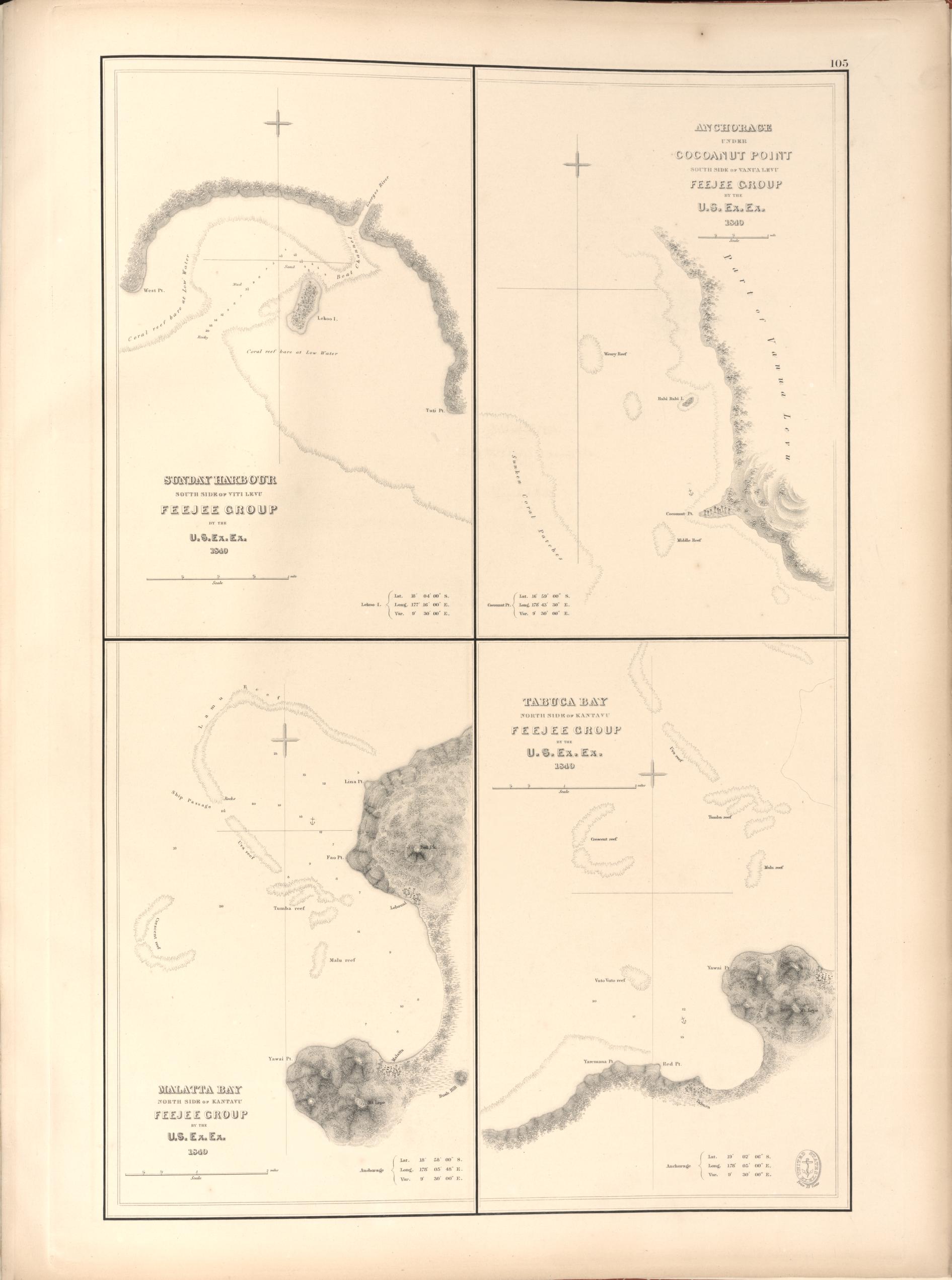
Sunday Harbor, Anchorage under Cocoanut Point, and Malatta and Tabuka Bays, Feejee Islands, 105
Port Ridgely, Tubou Harbor, and Wailevu or Peale's River, Feejee Islands, 106

56 U.S. EX. EX. - ATLAS OF CHARTS, VOL.II.

Chart of Phoenix Group by the U.S.Ex.Ex. 1840.41.

Chart of Phoenix Group by the U.S.Ex.Ex. 1840.41.
[Click on image to enlarge.]

U.S. EX. EX. - ATLAS OF CHARTS, VOL.II. 57

Swain's Island by the U.S. Ex.Ex. 1841; Jarvis' Island by the U.S. Ex.Ex. 1841; Birnies Island, Phoenix Group by the U.S. Ex.Ex. 1841; Enderbury' Island, Phoenix Group by the U.S. Ex.Ex. 1840; Hull's Island, Phoenix Group by the U.S. Ex.Ex. 1840; New-York or Washington Island by the U.S. Ex.Ex. 1840.

Swain's Island by the U.S. Ex.Ex. 1841;
Jarvis' Island by the U.S. Ex.Ex. 1841;
Birnies Island, Phoenix Group by the U.S. Ex.Ex. 1841;
Enderbury' Island, Phoenix Group by the U.S. Ex.Ex. 1840;
Hull's Island, Phoenix Group by the U.S. Ex.Ex. 1840;
New-York or Washington Island by the U.S. Ex.Ex. 1840.
[Click on image to enlarge.]

58 U.S. EX. EX. - ATLAS OF CHARTS, VOL.II.

Fakaafoor Bowditch Island by the U.S. Ex.Ex. 1841; Nuku-nono or Duke of Clarence Island by the U.S. Ex.Ex. 1841; Oatafu or Duke of York Island by the U.S. Ex.Ex. 1841.

Fakaafoor Bowditch Island by the U.S. Ex.Ex. 1841;
Nuku-nono or Duke of Clarence Island by the U.S. Ex.Ex. 1841;
Oatafu or Duke of York Island by the U.S. Ex.Ex. 1841.
[Click on image to enlarge.]

U.S. EX. EX. - ATLAS OF CHARTS, VOL.II. 59

Funafuti or Ellices Island by the U.S. Ex.Ex. 1841;<br />
Nukufetau or De Peysters Island by the U.S. Ex.Ex. 1841;<br />
Ellices Group by the U.S. Ex.Ex. 1841.

Funafuti or Ellices Island by the U.S. Ex.Ex. 1841;
Nukufetau or De Peysters Island by the U.S. Ex.Ex. 1841;
Ellices Group by the U.S. Ex.Ex. 1841.
[Click on image to enlarge.]

60 U.S. EX. EX. - ATLAS OF CHARTS, VOL.II.

Bigini or Pesadores Island by the U.S.Ex.Ex. 1841; Radogaia and Korsakoff Islands by the U.S. Ex.Ex. 1841.

Bigini or Pesadores Island by the U.S.Ex.Ex. 1841;
Radogaia and Korsakoff Islands by the U.S. Ex.Ex. 1841.
[Click on image to enlarge.]

U.S. EX. EX. - ATLAS OF CHARTS, VOL.II. 61

 Map of Hawaiian Group, or Sandwich Islands by the U.S. Ex.Ex. 1841.

Map of Hawaiian Group, or Sandwich Islands by the U.S. Ex.Ex. 1841.
[Click on image to enlarge.]

62 U.S. EX. EX. - ATLAS OF CHARTS, VOL.II.

Map of Part of the Island of Hawaii, Sandwich Islands, Shewing the Craters and Eruption of May and June 1840, by the U.S. Ex.Ex. 1841.

Map of Part of the Island of Hawaii, Sandwich Islands, Shewing the Craters and Eruption of May and June 1840, by the U.S. Ex.Ex. 1841.
[Click on image to enlarge.]

U.S. EX. EX. - ATLAS OF CHARTS, VOL.II. 63

Chart of the Harbour of Waiakea, Island of Hawaii. Surveyed by the U.S. Ex.Ex. 1841.

Chart of the Harbour of Waiakea, Island of Hawaii. Surveyed by the U.S. Ex.Ex. 1841.
[Click on image to enlarge.]

64 U.S. EX. EX. - ATLAS OF CHARTS, VOL.II.

Gardner's or Kemin's Island, Phoenix Group by the U.S. Ex.Ex. 1840; Flint's Island by the U.S. Ex.Ex. 1841; McKean's Island, Phoenix Group by the U.S. Ex.Ex. 1840; Maro Reef by the U.S. Ex.Ex. 1841; Lahaina Roads, Island of Maui by the U.S. Ex.Ex. 1841.

Gardner's or Kemin's Island, Phoenix Group by the U.S. Ex.Ex. 1840;
Flint's Island by the U.S. Ex.Ex. 1841;
McKean's Island, Phoenix Group by the U.S. Ex.Ex. 1840;
Maro Reef by the U.S. Ex.Ex. 1841;
Lahaina Roads, Island of Maui by the U.S. Ex.Ex. 1841.
[Click on image to enlarge.]

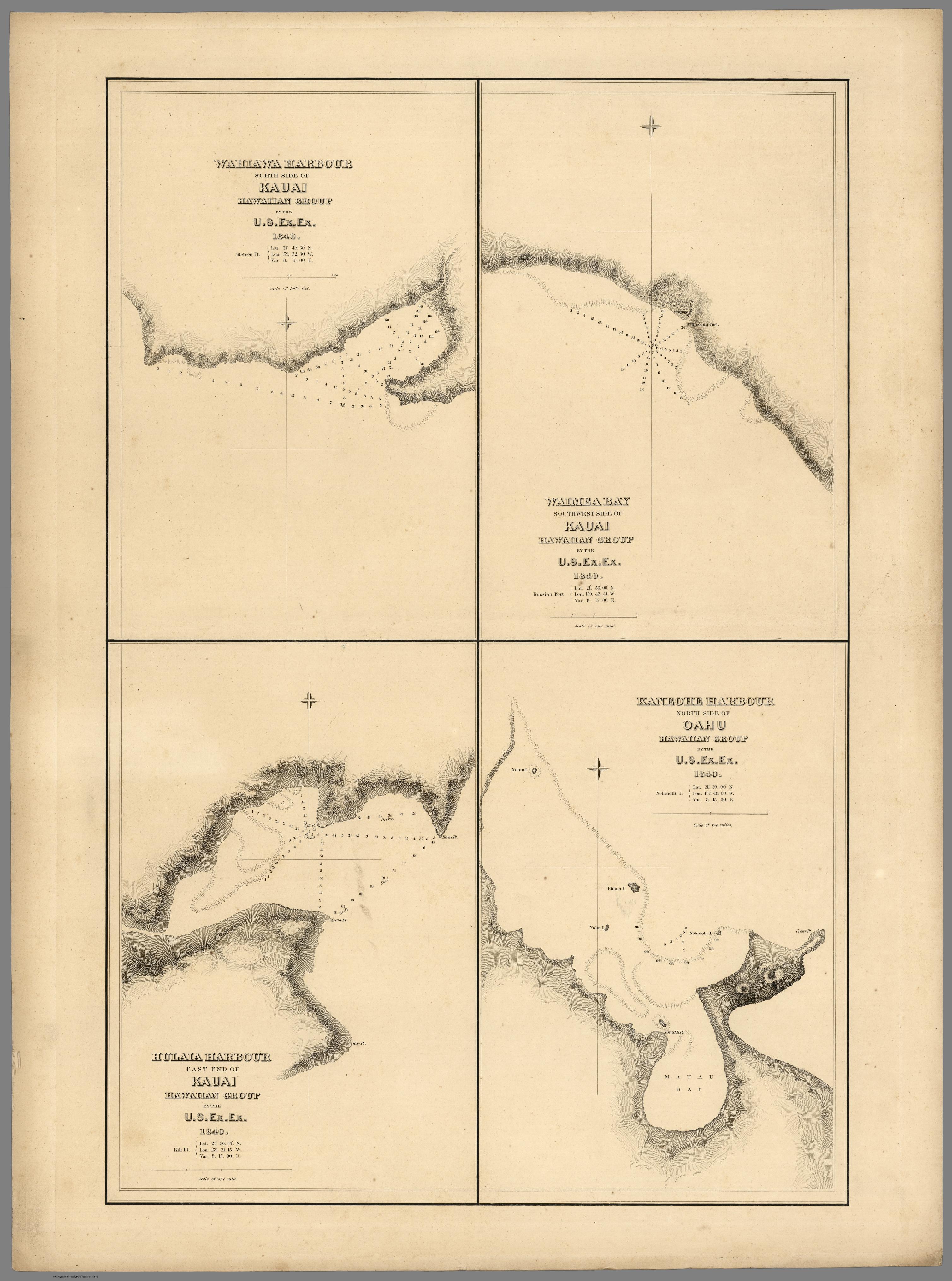
U.S. EX. EX. - ATLAS OF CHARTS, VOL.II. 65

Wahiawa Harbour, South side of Kauai, Hawaiian Group by the U.S. Ex.Ex. 1840; Waimea Bay, Southwest side of Kauai, Hawaiian Group by the U.S. Ex.Ex. 1840; Hulaia Harbour, East end of Kauai, Hawaiian Group by the U.S. Ex.Ex. 1840; Kaneohe Harbour, North side of Oahu, Hawaiian Group by the U.S. Ex.Ex. 1840.

Wahiawa Harbour, South side of Kauai, Hawaiian Group by the U.S. Ex.Ex. 1840;
Waimea Bay, Southwest side of Kauai, Hawaiian Group by the U.S. Ex.Ex. 1840;
Hulaia Harbour, East end of Kauai, Hawaiian Group by the U.S. Ex.Ex. 1840;
Kaneohe Harbour, North side of Oahu, Hawaiian Group by the U.S. Ex.Ex. 1840.
[Click on image to enlarge.]

66 U.S. EX. EX. - ATLAS OF CHARTS, VOL.II.

 Harbour of Ewa or Pearl River, Island of Oahu, Hawaiian Islands by the U.S. Ex.Ex. 1840; Harbour of Honolulu, Island of Oahu, Hawaiian Islands by the U.S. Ex.Ex. 1840.

Harbour of Ewa or Pearl River, Island of Oahu, Hawaiian Islands by the U.S. Ex.Ex. 1840;
Harbour of Honolulu, Island of Oahu, Hawaiian Islands by the U.S. Ex.Ex. 1840.
[Click on image to enlarge.]

U.S. EX. EX. - ATLAS OF CHARTS, VOL.II. 67

Map of the Oregon Territory by the U.S. Ex. Ex., Charles Wilkes Esqr., Commander. 1841; Inset: Columbia River, reduced from a survey made by the U.S. Ex. Ex. 1841.

Map of the Oregon Territory by the U.S. Ex. Ex., Charles Wilkes Esqr., Commander. 1841;
Inset: Columbia River, reduced from a survey made by the U.S. Ex. Ex. 1841.
[Click on image to enlarge.]

68 U.S. EX. EX. - ATLAS OF CHARTS, VOL.II.

Sheet No. 1: Mouth of the Columbia River, Oregon Territory. Surveyed by the U.S. Ex. Ex., Charles Wilkes Esqr., Commander. 1841.

Sheet No. 1: Mouth of the Columbia River, Oregon Territory. Surveyed by the U.S. Ex. Ex., Charles Wilkes Esqr., Commander. 1841.
[Click on image to enlarge.]

U.S. EX. EX. - ATLAS OF CHARTS, VOL.II. 69

Sheet No. 2. of Columbia River from Astoria to Katalamet Head by the U.S. Ex.Ex. 1841.

Sheet No. 2. of Columbia River from Astoria to Katalamet Head by the U.S. Ex.Ex. 1841.
[Click on image to enlarge.]

70 U.S. EX. EX. - ATLAS OF CHARTS, VOL.II.

Sheet No. 3. of Columbia River by the U.S. Ex.Ex. 1841.

Sheet No. 3. of Columbia River by the U.S. Ex.Ex. 1841.
[Click on image to enlarge.]

U.S. EX. EX. - ATLAS OF CHARTS, VOL.II. 71

Sheet No. 4. of Columbia River by the U.S. Ex.Ex. 1841.

Sheet No. 4. of Columbia River by the U.S. Ex.Ex. 1841.
[Click on image to enlarge.]

72 U.S. EX. EX. - ATLAS OF CHARTS, VOL.II.

Sheet No. 5. of Columbia River by the U.S. Ex.Ex. 1841.

Sheet No. 5. of Columbia River by the U.S. Ex.Ex. 1841.
[Click on image to enlarge.]

U.S. EX. EX. - ATLAS OF CHARTS, VOL.II. 73

Sheet No. 6. of Columbia River by the U.S. Ex.Ex. 1841.

Sheet No. 6. of Columbia River by the U.S. Ex.Ex. 1841.
[Click on image to enlarge.]

74 U.S. EX. EX. - ATLAS OF CHARTS, VOL.II.

Sheet No. 7. of Columbia River by the U.S. Ex.Ex. 1841; Willamette River and Wapauto Branch, or Lower Willamette by the U.S. Ex.Ex. 1841.

Sheet No. 7. of Columbia River by the U.S. Ex.Ex. 1841;
Willamette River and Wapauto Branch, or Lower Willamette by the U.S. Ex.Ex. 1841.
[Click on image to enlarge.]

U.S. EX. EX. - ATLAS OF CHARTS, VOL.II. 75

Grays Harbour, Oregon Territory, by the U.S. Ex.Ex. 1841.

Grays Harbour, Oregon Territory, by the U.S. Ex.Ex. 1841.
[Click on image to enlarge.]

76 U.S. EX. EX. - ATLAS OF CHARTS, VOL.II.

Straits of Juan de Fuca, Oregon Territory, from Surveys of the U.S. Ex.Ex. and Spanish and English authorities, 1841.

Straits of Juan de Fuca, Oregon Territory, from Surveys of the U.S. Ex.Ex. and Spanish and English authorities, 1841.
[Click on image to enlarge.]

U.S. EX. EX. - ATLAS OF CHARTS, VOL.II. 77

 Archipelago of Arro, Gulf of Georgia, Ringgolds Channel, and Straits of Fuca, Oregon Territory. by the U.S. Ex.Ex. 1841; Inset: Fraser's River.

Archipelago of Arro, Gulf of Georgia, Ringgolds Channel, and Straits of Fuca, Oregon Territory. by the U.S. Ex.Ex. 1841;
Inset: Fraser's River.
[Click on image to enlarge.]

78 U.S. EX. EX. - ATLAS OF CHARTS, VOL.II.

Chart of Admiralty Inlet, Puget Sound, and Hoods Canal, Oregon Territory by the U.S. Ex.Ex. 1841.

Chart of Admiralty Inlet, Puget Sound, and Hoods Canal, Oregon Territory by the U.S. Ex.Ex. 1841.
[Click on image to enlarge.]

U.S. EX. EX. - ATLAS OF CHARTS, VOL.II. 79

Chart of Puget Sound, its Inlets and Anchorges by the U.S. Ex.Ex. 1841.

Chart of Puget Sound, its Inlets and Anchorges by the U.S. Ex.Ex. 1841.
[Click on image to enlarge.]

80 U.S. EX. EX. - ATLAS OF CHARTS, VOL.II.

St. Juan Harbour, Straits of Fuca, Vancouver Island by the U.S. Ex.Ex. 1841; Scarborough Harbour, Straits of Fuca, Oregon Territory by the U.S. Ex.Ex. 1841; Port Discovery, Straits of Fuca, Oregon Territory by the U.S. Ex.Ex. 1841.

St. Juan Harbour, Straits of Fuca, Vancouver Island by the U.S. Ex.Ex. 1841;
Scarborough Harbour, Straits of Fuca, Oregon Territory by the U.S. Ex.Ex. 1841;
Port Discovery, Straits of Fuca, Oregon Territory by the U.S. Ex.Ex. 1841.
[Click on image to enlarge.]

U.S. EX. EX. - ATLAS OF CHARTS, VOL.II. 81

New Dungeness Roads and Budd's Harbour, Straits of Fuca, Oregon Territory by the U.S. Ex.Ex. 1841.

New Dungeness Roads and Budd's Harbour, Straits of Fuca, Oregon Territory by the U.S. Ex.Ex. 1841.
[Click on image to enlarge.]

82 U.S. EX. EX. - ATLAS OF CHARTS, VOL.II.

Harbours in Admiralty Inlet, Oregon Territory by the U.S. Ex.Ex. 1841.

Harbours in Admiralty Inlet, Oregon Territory by the U.S. Ex.Ex. 1841.
[Click on image to enlarge.]

U.S. EX. EX. - ATLAS OF CHARTS, VOL.II. 83

Port Ludlow, Hoods Canal, Oregon Territory by the U.S. Ex.Ex. 1841; Port Gamble, Hoods Canal, Oregon Territory by the U.S. Ex.Ex. 1841

Port Ludlow, Hoods Canal, Oregon Territory by the U.S. Ex.Ex. 1841;
Port Gamble, Hoods Canal, Oregon Territory by the U.S. Ex.Ex. 1841.
[Click on image to enlarge.]

84 U.S. EX. EX. - ATLAS OF CHARTS, VOL.II.

Colsee-ed Harbour, Hoods Canal, Oregon Territory by the U.S. Ex.Ex. 1841; Suquamish Harbour, Hoods Canal, Oregon Territory by the U.S. Ex.Ex. 1841.

Colsee-ed Harbour, Hoods Canal, Oregon Territory by the U.S. Ex.Ex. 1841;
Suquamish Harbour, Hoods Canal, Oregon Territory by the U.S. Ex.Ex. 1841.
[Click on image to enlarge.]

U.S. EX. EX. - ATLAS OF CHARTS, VOL.II. 85

 Hooetzen Harbour, Hoods Canal, Oregon Territory by the U.S. Ex.Ex. 1841; Tzu-sa-ted Cove, Hoods Canal, Oregon Territory by the U.S. Ex.Ex. 1841; Scabock Harbour, Hoods Canal, Oregon Territory by the U.S. Ex.Ex. 1841.

Hooetzen Harbour, Hoods Canal, Oregon Territory by the U.S. Ex.Ex. 1841;
Tzu-sa-ted Cove, Hoods Canal, Oregon Territory by the U.S. Ex.Ex. 1841;
Scabock Harbour, Hoods Canal, Oregon Territory by the U.S. Ex.Ex. 1841.
[Click on image to enlarge.]

86 U.S. EX. EX. - ATLAS OF CHARTS, VOL.II.

 Case's Inlet, Puget Sound, Oregon Territory by the U.S. Ex.Ex. 1841; Carr's Inlet, Puget Sound, Oregon Territory by the U.S. Ex.Ex. 1841.

Case's Inlet, Puget Sound, Oregon Territory by the U.S. Ex.Ex. 1841;
Carr's Inlet, Puget Sound, Oregon Territory by the U.S. Ex.Ex. 1841.
[Click on image to enlarge.]

U.S. EX. EX. - ATLAS OF CHARTS, VOL.II. 87

The Narrows at the Entrance of Puget Sound with Commencement Bay, Colvos' Passage and a Part of Admiralty Inlet, Oregon Territory by the U.S. Ex.Ex. 1841.

The Narrows at the Entrance of Puget Sound with Commencement Bay, Colvos' Passage and a Part of Admiralty Inlet, Oregon Territory by the U.S. Ex.Ex. 1841.
[Click on image to enlarge.]

88 U.S. EX. EX. - ATLAS OF CHARTS, VOL.II.

Ports Orchard and Madison, Including the Inlets and Passages between them in Admiralty Inlet, Oregon Territory by the U.S. Ex.Ex. 1841.

Ports Orchard and Madison, Including the Inlets and Passages between them in Admiralty Inlet, Oregon Territory by the U.S. Ex.Ex. 1841.
[Click on image to enlarge.]

U.S. EX. EX. - ATLAS OF CHARTS, VOL.II. 89

Apple Cove, West side, Admiralty Inlet, Oregon Territory by the U.S. Ex.Ex. 1841; Port Gardner, Admiralty Inlet, Oregon Territory by the U.S. Ex.Ex. 1841; Port Susan, Admiralty Inlet, Oregon Territory by the U.S. Ex.Ex. 1841; Pilot Cove, West side, Admiralty Inlet, Oregon Territory by the U.S. Ex.Ex. 1841.

Apple Cove, West side, Admiralty Inlet, Oregon Territory by the U.S. Ex.Ex. 1841;
Port Gardner, Admiralty Inlet, Oregon Territory by the U.S. Ex.Ex. 1841;
Port Susan, Admiralty Inlet, Oregon Territory by the U.S. Ex.Ex. 1841;
Pilot Cove, West side, Admiralty Inlet, Oregon Territory by the U.S. Ex.Ex. 1841.
[Click on image to enlarge.]

90 U.S. EX. EX. - ATLAS OF CHARTS, VOL.II.

Deception Passage, Oregon Territory by the U.S. Ex.Ex. 1841; Penn's Cove, Whidbys Island, Oregon Territory by the U.S. Ex.Ex. 1841; Holmes's Harbour, Whidbys Island, Oregon Territory by the U.S. Ex.Ex. 1841.

Deception Passage, Oregon Territory by the U.S. Ex.Ex. 1841;
Penn's Cove, Whidbys Island, Oregon Territory by the U.S. Ex.Ex. 1841;
Holmes's Harbour, Whidbys Island, Oregon Territory by the U.S. Ex.Ex. 1841.
[Click on image to enlarge.]

U.S. EX. EX. - ATLAS OF CHARTS, VOL.II. 91

Anchorage at Point Roberts, Oregon Territory by the U.S. Ex.Ex. 1841; Birch Bay, Oregon Territory by the U.S. Ex.Ex. 1841; Drayton's Bay, Oregon Territory by the U.S. Ex.Ex. 1841.

Anchorage at Point Roberts, Oregon Territory by the U.S. Ex.Ex. 1841;
Birch Bay, Oregon Territory by the U.S. Ex.Ex. 1841;
Drayton's Bay, Oregon Territory by the U.S. Ex.Ex. 1841.
[Click on image to enlarge.]

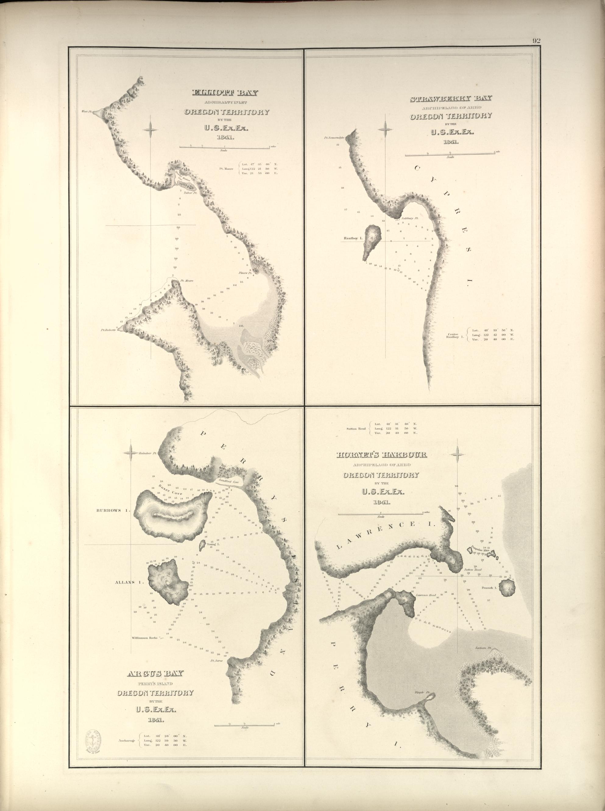
92 U.S. EX. EX. - ATLAS OF CHARTS, VOL.II.

Elliott Bay, Admiralty Inlet, Oregon Territory by the U.S. Ex.Ex. 1841; Strawberry Bay, Archipelago of Arro, Oregon Territory by the U.S. Ex.Ex. 1841; Argus Bay, Perry's Island, Oregon Territory by the U.S. Ex.Ex. 1841; Hornet's Harbour, Archipelago of Arro, Oregon Territory by the U.S. Ex.Ex. 1841.

Elliott Bay, Admiralty Inlet, Oregon Territory by the U.S. Ex.Ex. 1841;
Strawberry Bay, Archipelago of Arro, Oregon Territory by the U.S. Ex.Ex. 1841;
Argus Bay, Perry's Island, Oregon Territory by the U.S. Ex.Ex. 1841;
Hornet's Harbour, Archipelago of Arro, Oregon Territory by the U.S. Ex.Ex. 1841.
[Click on image to enlarge.]

U.S. EX. EX. - ATLAS OF CHARTS, VOL.II. 93

Map of Sacramento River and Bay of San Pablo with Harbour of San Francisco by the U.S. Ex.Ex. 1841; Inset: Entrance to the Harbour of San Francisco.

Map of Sacramento River and Bay of San Pablo with Harbour of San Francisco by the U.S. Ex.Ex. 1841;
Inset: Entrance to the Harbour of San Francisco.
[Click on image to enlarge.]

94 U.S. EX. EX. - ATLAS OF CHARTS, VOL.II.

Wake's Island by the U.S. Ex.Ex. 1841; Turtle Island by the U.S. Ex.Ex. 1840; Taloo Harbour, Island of Eimeo by the U.S. Ex.Ex. 1839; Uea or Wallis Island by the U.S. Ex.Ex. 1839.

Wake's Island by the U.S. Ex.Ex. 1841;
Turtle Island by the U.S. Ex.Ex. 1840;
Taloo Harbour, Island of Eimeo by the U.S. Ex.Ex. 1839;
Uea or Wallis Island by the U.S. Ex.Ex. 1839.
[Click on image to enlarge.]

U.S. EX. EX. - ATLAS OF CHARTS, VOL.II. 95

Chart of the Sooloo Sea by the U.S. Ex.Ex. and from the best recent authorities. 1842.

Chart of the Sooloo Sea by the U.S. Ex.Ex. and from the best recent authorities. 1842.
[Click on image to enlarge.]

96 U.S. EX. EX. - ATLAS OF CHARTS, VOL.II.

Chart of Sooloo Island and Adjacent Islands by the U.S. Ex.Ex. and Spanish authorities. 1841.

Chart of Sooloo Island and Adjacent Islands by the U.S. Ex.Ex. and Spanish authorities. 1841.
[Click on image to enlarge.]

U.S. EX. EX. - ATLAS OF CHARTS, VOL.II. 97

Straits of Mindoro, Sooloo Sea, by the U.S. Ex.Ex. 1841; Inlet: Apo Shoal; Tongataboo Harbour, Island of Tongataboo. By the U.S. Ex.Ex. 1840.

Straits of Mindoro, Sooloo Sea, by the U.S. Ex.Ex. 1841;
Inlet: Apo Shoal;
Tongataboo Harbour, Island of Tongataboo. By the U.S. Ex.Ex. 1840.
[Click on image to enlarge.]

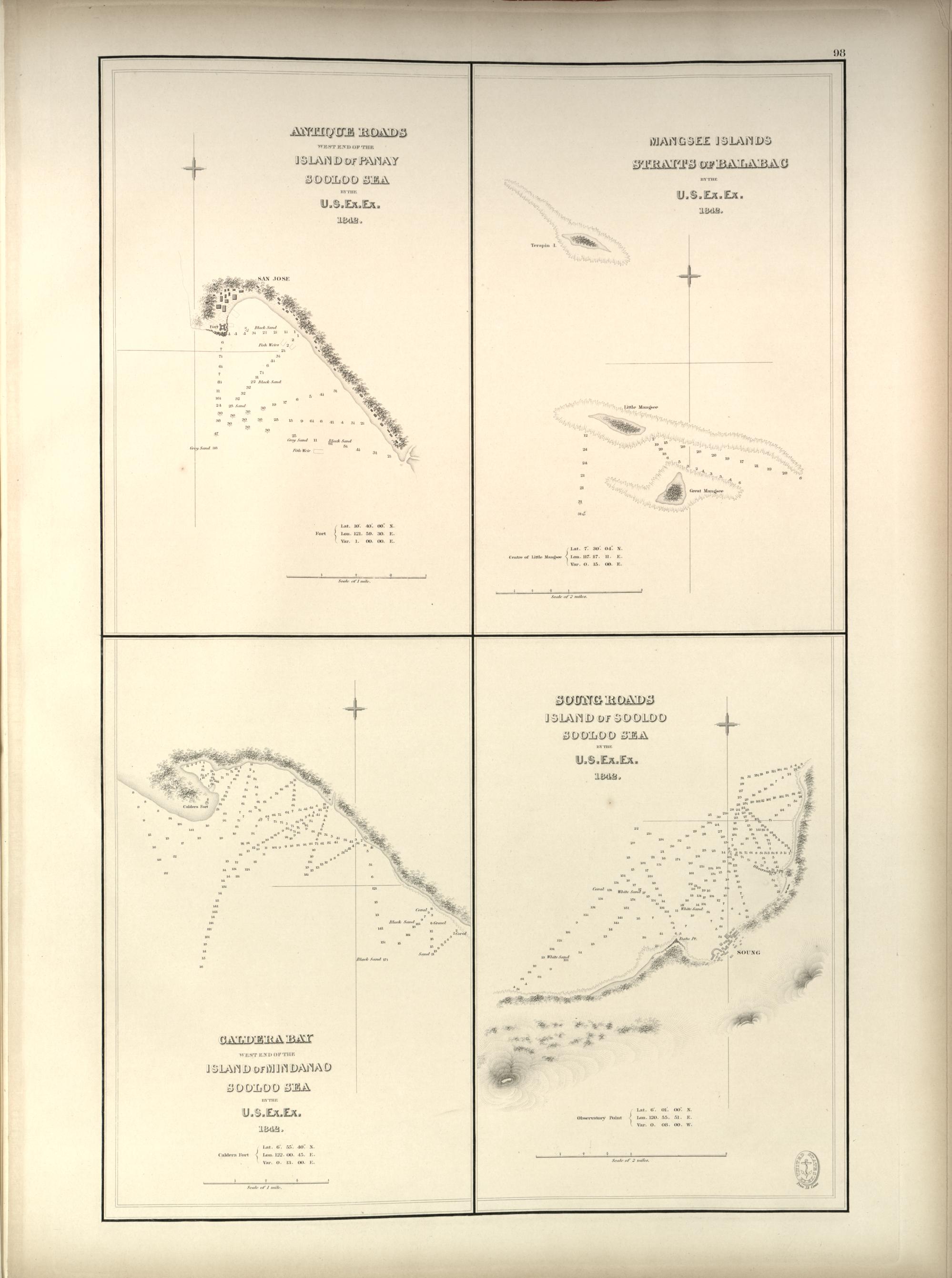
98 U.S. EX. EX. - ATLAS OF CHARTS, VOL.II.

Antique Roads, West end of the Island of Panay, Sooloo Sea by the U.S. Ex.Ex. 1842; Mangsee Islands, Straits of Balabac by the U.S. Ex.Ex. 1842; Caldera Bay, West end of the Island of Mindanao, Sooloo Sea by the U.S. Ex.Ex. 1842; Soung Roads, Island of Sooloo, Sooloo Sea by the U.S. Ex.Ex. 1842.

Antique Roads, West end of the Island of Panay, Sooloo Sea by the U.S. Ex.Ex. 1842;
Mangsee Islands, Straits of Balabac by the U.S. Ex.Ex. 1842;
Caldera Bay, West end of the Island of Mindanao, Sooloo Sea by the U.S. Ex.Ex. 1842;
Soung Roads, Island of Sooloo, Sooloo Sea by the U.S. Ex.Ex. 1842.
[Click on image to enlarge.]

U.S. EX. EX. - ATLAS OF CHARTS, VOL.II. 99

Chart of the Straits of Balabac or Western Entrance to the Sooloo Sea by the U.S. Ex.Ex. 1842.

Chart of the Straits of Balabac or Western Entrance to the Sooloo Sea by the U.S. Ex.Ex. 1842.
[Click on image to enlarge.]

100 U.S. EX. EX. - ATLAS OF CHARTS, VOL.II.

Chart of the Straits of Basillan and Islands by the U.S. Ex.Ex. and the best authorities. 1842.

Chart of the Straits of Basillan and Islands by the U.S. Ex.Ex. and the best authorities. 1842.
[Click on image to enlarge.]

U.S. EX. EX. - ATLAS OF CHARTS, VOL.II. 101

Chart of the Straits of Rhio by the U.S. Ex. Ex. and the best Dutch, English and Native Authorities 1842.

Chart of the Straits of Rhio by the U.S. Ex. Ex. and the best Dutch, English and Native Authorities 1842.
[Click on image to enlarge.]

102 U.S. EX. EX. - ATLAS OF CHARTS, VOL.II.

South and East Side of Vanua Levu from Savu Savu Bay to Natava Bay, Feejee Islands by the U.S. Ex.Ex. 1840.

South and East Side of Vanua Levu from Savu Savu Bay to Natava Bay, Feejee Islands by the U.S. Ex.Ex. 1840.
[Click on image to enlarge.]

U.S. EX. EX. - ATLAS OF CHARTS, VOL.II. 103

Island of Vatulele, Feejee Group by the U.S. Ex.Ex. 1840; Island of Vanua Vatu, Feejee Group by the U.S. Ex.Ex. 1840; Tova Reef, Feejee Group by the U.S. Ex.Ex. 1840

Island of Vatulele, Feejee Group by the U.S. Ex.Ex. 1840;
Island of Vanua Vatu, Feejee Group by the U.S. Ex.Ex. 1840;
Tova Reef, Feejee Group by the U.S. Ex.Ex. 1840
[Click on image to enlarge.]

104 U.S. EX. EX. - ATLAS OF CHARTS, VOL.II.

Nemena or Direction Island, Feejee Group by the U.S. Ex.Ex. 1840; Horseshoe Reef, Feejee Group by the U.S. Ex.Ex. 1840; Ambatiki Island, Feejee Group by the U.S. Ex.Ex. 1840.

Nemena or Direction Island, Feejee Group by the U.S. Ex.Ex. 1840;
Horseshoe Reef, Feejee Group by the U.S. Ex.Ex. 1840;
Ambatiki Island, Feejee Group by the U.S. Ex.Ex. 1840.
[Click on image to enlarge.]

U.S. EX. EX. - ATLAS OF CHARTS, VOL.II. 105

Sunday Harbor, South side of Viti Levu, Feejee Group by the U.S. Ex.Ex. 1840; Anchorage under Cocoanut Point, South side of Vanua Levu, Feejee Group by the U.S. Ex.Ex. 1840; Malatta Bay, North Side of Kantavu, Feejee Group by the U.S. Ex.Ex. 1840; Tabuka Bay, North Side of Kantavu, Feejee Group by the U.S. Ex.Ex. 1840.

Sunday Harbor, South side of Viti Levu, Feejee Group by the U.S. Ex.Ex. 1840;
Anchorage under Cocoanut Point, South side of Vanua Levu, Feejee Group by the U.S. Ex.Ex. 1840;
Malatta Bay, North Side of Kantavu, Feejee Group by the U.S. Ex.Ex. 1840;
Tabuka Bay, North Side of Kantavu, Feejee Group by the U.S. Ex.Ex. 1840.
[Click on image to enlarge.]

106 U.S. EX. EX. - ATLAS OF CHARTS, VOL.II.

Port Ridgely, Vanua Valavo, Feejee Islands by the U.S. Ex.Ex. 1840; Tubou Harbour, Tasmans Straits, Feejee Islands by the U.S. Ex.Ex. 1840; Wailevu or Peale's River, Viti Levu by the U.S. Ex.Ex. 1840.

Port Ridgely, Vanua Valavo, Feejee Islands by the U.S. Ex.Ex. 1840;
Tubou Harbour, Tasmans Straits, Feejee Islands by the U.S. Ex.Ex. 1840;
Wailevu or Peale's River, Viti Levu by the U.S. Ex.Ex. 1840.
[Click on image to enlarge.]

Source.
Wilkes, Charles.
      Narrative of the United States exploring expedition. During the years 1838, 1839, 1840, 1841, 1842. Atlas of charts. Vol. II.
Philadelphia: C. Sherman, 1858.
    2 p.l.; 51 numbered charts (13 double-page).


Last updated by Tom Tyler, Denver, CO, USA, February 08, 2025

Previous AnthologySourceWhalesite Next