|
CURRENTS AND WHALING.Charles Wilkes. |
|
. . . .
|
|
CHAPTER XII
CONTENTS. connexion of the subjects – opportunities and means of observing currents – distinction between streams and currents – currents of the north atlantic – labrador stream – gulf stream – rennell current – submarine polar streams – guinea stream – equatorial stream – recapitulation – sargasso sea – streams of the south atlantic – brazil stream – patagonian stream – south african stream – phenomena of the neighbourhood of st. helena – polar stream off cape horn – its low submarine temperature – chili stream – phenomena at the gallipagos islands – indication of submarine polar streams – phenomena at the society islands – at the samoan group – at the feejee group – australian stream – southern polar stream – new zealand currents – currents between tonga and feejee-sudden rush of waters on the polynesian islands-space of very elevated temperature – pacific equatorial streams – phenomena of the sandwich islands – streams of the northwest coast – japan stream – currents of the china seas – of the east coast of africa – equatorial stream of the indian ocean – currents of the malabar coast, chagos, and comorro islands – streams of the mozambique channel – equatorial stream of the south atlantic – general view of the facts – zones of calms and still waters – suggestions in relation to the theory of currents – connexion of the ocean streams with the migrations of the sperm whale – importance and extent of the whaling interest – cruising-grounds of sperm whalers – in the pacific – in the atlantic – in the indian ocean – directions for whaling in the pacific – relative to the decrease of whales – right whale fishery – depraved character of the new zealand and australian whalers – case of the american whale-ship adeline – right whale fishery in high latitudes – excitement of the fishery – slaughter and treatment of the products – profits of the business – frequency of disputes between the masters and crews – remedies suggested – proposal for the improvement of the morals and condition of tne crews. (455)
|
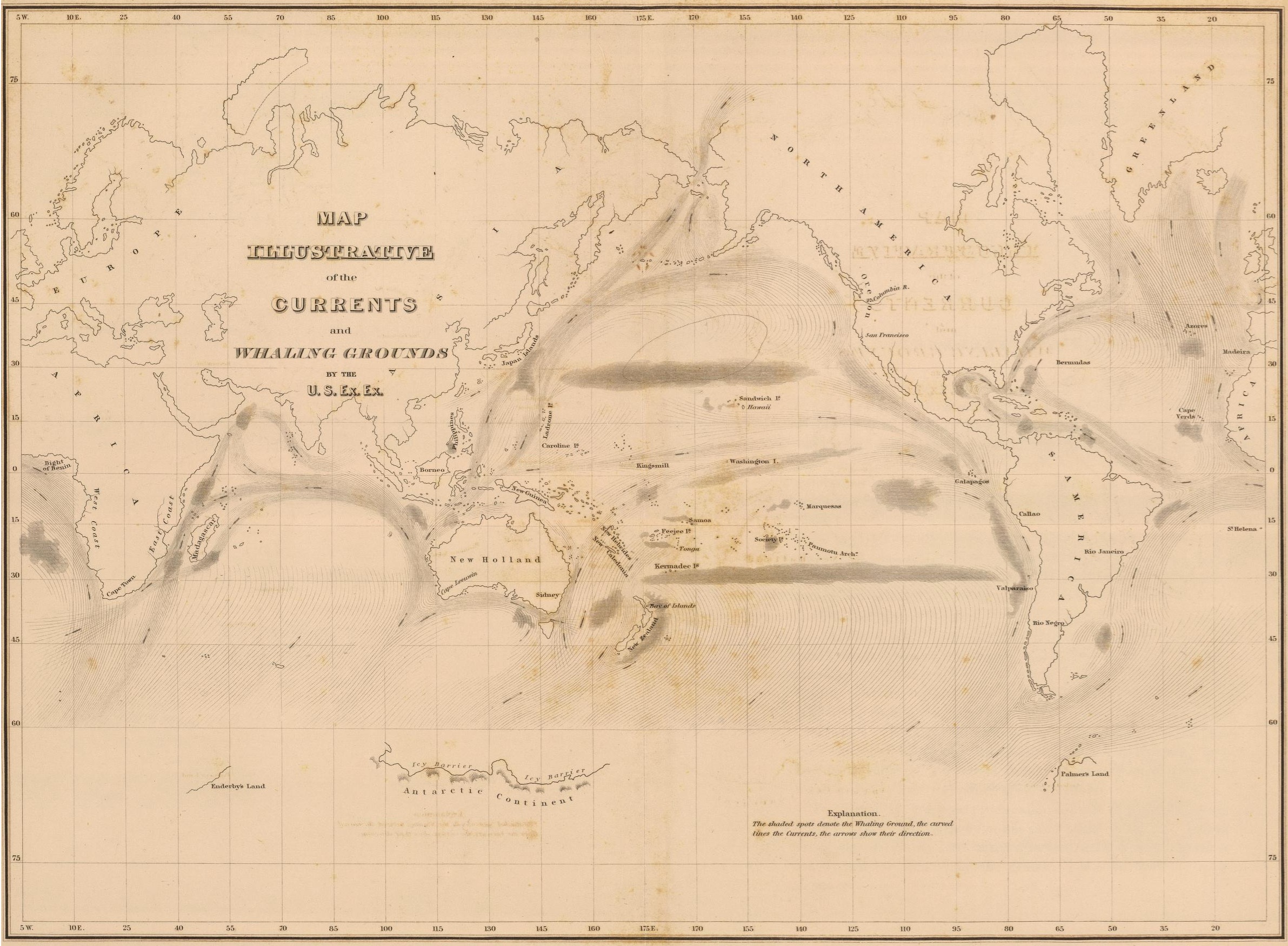
Map Illustrative of the Currents and Whaling Grounds by he U.S.Ex.Ex.
|
|
CHAPTER XII.
CURRENTS AND WHALING. It may at first sight appear singular that subjects apparently so dissimilar as currents and whaling should be united to form the subject of one chapter. Before its conclusion, however, we trust to establish satisfactorily that the course of the great currents of the ocean, sweeping with 'them the proper food of the great cetaceous animals, determines not only the places to which they are in the habit of resorting, but the seasons at which they are to be found frequenting them. In the devious and extensive cruise performed by the Exploring Expedition, many, and perhaps greater opportunities than had before been enjoyed by any one vessel or squadron were afforded for investigating the course and direction of currents. The field of research thus opened proved to be so vast that I cannot but regret that we had not possessed still greater facilities for prosecuting the inquiry than we could attain even in a voyage of such long duration. In particular, simultaneous observations in different parts of the ocean, and their continuance for months or even for the whole year, were requisite to render the results, that I believe I have attained, more satisfactory and conclusive. Enough, however, has I hope been done to excite the curiosity and rouse the attention of future navigators, by whose labours a sufficient number of facts may be collected upon which to found a theory that will admit of no question. To obtain the greatest practicable number of experiments with the cuirent log, of which mention has been made in the first chapter, was an object which claimed early attention, and which was kept constantly in view throughout the cruise. I was however aware, as all |
those who have used this instrument extensively must be, that it is liable to many objections, and that in particular if the current be beneath the surface, or, for want of a better term, may be denominated submarine , no result can be obtained by its use. If not perfect, however, the current log was at least a useful indicator; and its regular use, which was ordered to take place whenever the state of the sea would permit, served to keep the subject of currents continually before us. It is unnecessary to recount the number of the experiments that were performed; suffice it to say, that they were made both by day and by night, and were persevered in until the record of them became an almost daily portion of our journals; and the interest in them was extended from the officers, until they became a subject of inquiry even among the crews. Upon the chart that exhibits the tracks of the squadron when united, and of the vessels when separate, the direction and force of the upper currents is indicated. The results thus expressed were obtained by a comparison of the position assigned to the vessels by the dead reckoning, and the true place shown by astronomic observations. This method, when practised by good observers, and particularly when furnished with chronometers of such excellence as can now be obtained, is in my opinion that which is liable to the fewest objections. Still it is to be desired that the allowances in the dead reckoning for lee-way, the heave of the sea, steerage, &c., should be founded on principles so certain as to admit them to be applied separately, and that less was left to the mere judgment of the navigator. The use of steam in navigation, and the introduction of improvements in the log, will probably bring about this desirable result. In order to attain greater certainty, every calculation on which the rate and direction of a current was founded, has been made anew since the return of the Expedition; and it is trusted that the chart now exhibits a full and correct representation of the action which influenced the position of the vessels, freed in a great measure from the causes of uncertainty of which I have spoken above. On the same chart are represented the courses of the winds, and the isothermal lines for every five degrees of the thermometer, from 30° to 95°. The zones lying between these lines are coloured in tints varying from cold to warm, in order that at a single glance the curves may be conspicuous. By simple inspection it will be seen how close is the connexion between the position of these lines and the figure of the zones they enclose, with the flow of the streams of which I am about to treat. It will at least be obvious that the distribution of the temperature at the surface of the ocean is affected by causes very |
different from those which are usually considered to be the only ones in action. In order to obtain precision of language, I have chosen to distinguish between streams and currents , employing the former term to express the movements of water by which the circulation of the great mass of the ocean is maintained, and confining the latter to those less extensive in their influence, or local in their effects; and the direction from whence the great streams are derived as polar and equatorial. I shall now proceed to speak of the streams which we met with on our voyage, citing, whenever it is necessary, such facts derived either from general experience, or the authority of individual observers, as may be useful to extend the inferences, or verify our own observations. Immediately after our departure from the capes of Virginia, we felt the influence of a stream setting to the southward, and parallel to the coast. The existence of this was apparent from our first observation of latitude. It may, however, often escape notiee, as the navigator is apt to ascribe the effect of this stream rather to an error in taking his departure, than to a set of current. In order that the fact may be clearly perceived, it is necessary that the distance of the vessel from the lighthouse, or other object on shore with which the dead reckoning begins, should be determined by precise observations, instead of being merely estimated, as is the usual mode. Notwithstanding the inaccuracy growing out of this cause, it has been long known to seamen that a counter-current is setting close to the inner edge of the Gulf Stream, and has been distinguished by them as its eddy. That it cannot be of the nature of an eddy of that heated body of water, is evident from the great difference of temperature, which falls suddenly fifteen or twenty degrees, in passing from the Gulf Stream into that which flows in an opposite direction. The latter is also five to ten, and even fifteen degrees colder, according to the season, than the waters of our bays or rivers. The inner stream flowing to the southwest is now well known to exist along our whole eastern coast and that of Nova Scotia, and the masters of our packet-ships have by experience discovered the value of which it may be to them in their homeward passage. This they do by keeping to the north of the forty-second parallel until off Cape Sable. Tracing this stream in a direction opposite to its course to the most distant part of Nova Scotia, it is found to be a part of one that flows southwards along the shore of Labrador, and which is well known by the name of that country. The Labrador Stream therefore flows along the coast of the New Continent, from Davis’s Straits as far to the south |
at least as Cape Hatteras. It is consequently of that character which is generally known as polar. One of the strongest facts in support of the extension of this stream to the farthest northern point we have named, lies in the transportation southward of vast masses of ice along the coast of Labrador, which are met annually in May, June, and July, off the banks of Newfoundland. This is a cause which affects in a most remarkable manner the climates of Newfoundland and Nova Scotia, and causes the harbours even of the latter country to remain ice-bound to a late period in the year. Nor is its influence believed to be of small amount in the climate of our Eastern, or that of the sea-coast of our Northern States. The phenomena of the icebergs develope another fact in relation to this current, namely, that where the influence of the current ceases to be felt upon the surface, the body of its waters still continues its course southwards beneath the flow of the Gulf Stream, which floats upon it precisely as the fresh water of the large rivers of the New World are to be seen for leagues from the shore flowing on the salt and denser water beneath. The phenomenon to which we have reference is, that icebergs near the Grand Banks have frequently been observed moving rapidly to the southward and westward, in places where ships experience a current to the northward and eastward. The icebergs, floating by the laws of specific gravity, with no more than one-tenth of their mass above the surface, evidently are carried onward by a stream flowing in the former direction, against whose force the action of the superficial current on a part of their surface is of no avail, while ships are wholly immersed in the latter, and obey its influence. Here then we have an instance of two currents flowing one above the other, in directions almost opposite to each other. The Labrador Stream, besides being overspread by the waters of the Gulf, the surface part of it is doubtless deflected from its flow to the southward, and forced along the eastern coast till it is obstructed very materially in the vicinity of George’s Bank. The position and supposed dangers of these banks, and the narrowness of the Labrador Stream in passing them, has prevented navigators from taking the full advantage they might have derived from their knowledge of its existence. Of the loss of time frequently growing out of this difficulty, I had myself an instance in a voyage from Europe in the winter of 1836-37. Captain Hebberd, who commanded the vessel in which I was passenger, feared that he might approach too near to the shoals of George’s Bank and Nantucket, and therefore, when opposed by a westerly wind, made tacks that carried him within |
the influence of the Gulf Stream. Since that tiftae, in the summer of 1837, I was employed in the survey of the shoal on George’s Bank, and after having explored every part of it, am satisfied that the alleged dangers do not exist to the extent believed. During the continuance of that survey, I spoke and made inquiries of many masters of coasters, all of whom confirmed the fact of the existence of a stream of cold water between the Gulf Stream and soundings. In this cold and favouring stream, vessels homeward-bound may be kept without difficulty or danger, by a due attention to the indications of the thermometer and lead-line: the former showing when the adverse stream of the Gulf is entered, the latter, when the variable currents of the shore are met with, or the dangers approached. In the navigation of this part of the ocean, great attention ought to be paid to keep within this stream, by all those who desire to effect a speedy passage from Europe. Circumstances afforded me a very favourable opportunity for observations upon the Gulf Stream. We met in it with light winds, which rendered our progress so slow, that we were forty-eight hours in crossing it, during thirty-nine of which we were sailing at right angles to its direction, a course the most favourable for the purpose. The remaining nine hours we were heading the stream. The fact of our having entered the stream was immediately detected by the thermometer, indicating a sudden rise of the temperature of the water; and the lightness of the wind enabled us to repeat the observations frequently. These observations are recorded in the following register.
|
It will thus be seen that the Gulf Stream is somewhat warmer towards its inner edge than it is on the outer. The calculations of the run of the ship gave fifty-three miles for the breadth of the Stream at the place where we crossed it, namely, on the parallel of 34° 30', and for its velocity about two miles per hour. All navigators, however, are aware of the fact, that both the breadth and velocity of the Gulf Stream vary much, and that it occasionally approaches much nearer to the coast than it does at other times. The approach of the Gulf Stream to our shores, has been ascribed to the influence of northeasterly winds. These are known to affect the tides in our bays and harbours, but I am unwilling to admit that these are an adequate cause for the change in position and velocity of so great a body of water. The action is far too trivial to account for such an effect. It is certain, on the other hand, that the Gulf and Labrador Streams both owe their existence to the unequal distribution of temperature on the earth’s surface; there must be a difference in the intensity of the causes that act to produce these effects at different seasons of the year, and it may be inferred that the changes of the seasons act unequally upon the two streams. The force of the portion of the Labrador Current, which follows the coast of the United States, will, when superior, carry the Gulf Stream outwards, and when that force diminishes, the Gulf Stream will approach more nearly to the coast, and most nearly when its own relative force is the greatest. Whatever be the ultimate causes of the streams, it would appear that |
their approximate causes are influenced by temperature—the Gulf Stream being increased in mass and velocity when the temperature is highest, and the Labrador Stream when it is lowest; and in conformity, we find it a general impression that the former is broader and more rapid in the summer of our climate than in winter. I must however state, that I have been unable from my own personal observation, either by the thermometer or the set of the vessel, to distinguish this increase of the Gulf Stream in summer. Thus in my passage to England, in August, 1836, from the time we passed to the eastward of George’s Bank, in a latitude about a degree to the south of it, we experienced a low temperature in the water, and the vessel was retarded. We were therefore in the Labrador Current. After the squadron had crossed the Gulf Stream, we experienced little action from current until we reached Madeira, the whole difference between our dead reckoning and the true place of the ship being no more than one hundred and seventy-five miles in twenty-six days. Before leaving this part of our subject, it may be as well to refer to facts familiarly known, but which did not come within the scope of our observations. The stream known on our coast by the epithet of Gulf, may often be traced upon the surface, but with diminished velocity, entirely across the Atlantic, throwing at some seasons the seeds and drift of tropical climates upon the British Islands, even as far north as the Shetlands. At other times, when the Gulf Stream ceases to flow, or is overpowered by the great Polar Current, they are carried by the latter to the southeastward, on the coast of Spain and Portugal, which current has been so disastrous by the number of vessels that have been wrecked on Cape Finisterre; where it divides, one branch of it passing around the shores of the Bay of Biscay, along the west coast of France, and thence crossing the English Channel, which is now well known as the Rennell Current; while the main Polar Stream flows southward, along the coast of Portugal towards Madeira, with a diminished velocity, as a surface current. That the stream which sets upon Cape Finisterre is the origin of the Rennell Current, the following remarks by Horsburgh clearly show. "The current is found to set eastward, from March to November, particularly when westerly winds prevail; and off Cape Finisterre, and near the south part of the Bay of Biscay, it sets mostly along the coast to the eastward; and along the east coast of the bay, it sets to the northward, parallel to the west coast of France." At Madeira and the Canary Islands the surface Polar Stream appears to have ceased; but by our observations on the deep-sea tempe- |
rature, a submarine stream still appears to exist. In lieu of the formei we have the current familiarly known as the African Current, by its causing so many distressing wrecks on that coast, and to which attention has often been drawn by the captivity and cruel slavery to which their crews have been subjected. As has been seen in the Narrative, but little surface current was found on our voyage from Madeira to the Cape de Verdes; but the submarine stream was still found, as was shown by the low temperatures of the deep-sea soundings. At, and in the neighbourhood of the latter islands, and between them and Cape Verde on the African coast, a strong surface current is felt. In endeavouring to account for this remarkable circumstance of the creation of a current, and its increased velocity, of which every navigator must be aware w T hen in the neighbourhood of many islands, and the effects of which we have often experienced in our long voyage, I shall now advert to the cause which I think is quite sufficient to produce the effect; and that is the accumulation of water caused by the obstructions that islands offer to the onward flow of submarine streams; thus raising the level of the ocean in their vicinity, and consequently a tendency to run off, and thereby cause a current where none was perceptible before, or an increased velocity in that which was felt. To this cause, then, I believe the currents around the Cape de Verde Islands owe their origin, as well as all others prevailing near islands and banks; and as corroborative proof of this I will mention the fact that where no submarine polar stream exists, permanent currents are not found. This will, I trust, be amply shown in the sequel. That remarkable current along the coast of Guinea, from which it derives its name, passing Cape Palmas, and flowing into the Bight of Benin, I attribute to the same cause. This current is in the immediate vicinity of the Equatorial Stream, but runs in an opposite direction, and for a long distance parallel to it. Of this current the following remarks were made by Colonel Sabine, when he passed it in H. B. M-ship Pheasant, Captain Clavering, in 1822 . "In the voyage between Cape Mount and Cape Three Points, in April and May, 1822 , the Pheasant’s progress appears to have been accelerated one hundred and eighty miles by the current called the Guinea Current, which, in the season when the southwest winds prevail on this part of the coast, runs with considerable velocity, in the direction of the land, from Cape Palmas to the eastern part of the Gulf of Guinea. The breadth of this current, abreast of Cape Palmas, varies with the season, and has been found as much as one hundred and eighty miles; but, in its subsequent course to the eastward, it |
enlarges to nearly three hundred, and occupies the whole space between the land on one side, and the Equatorial Current, running in an opposite direction, on the other. The velocity abreast of Cape Palmas and Cape Three Points, and in the vicinity of the land, was, in the month of May, about two mills in the hour; and farther to the eastward, where the Pheasant crossed its breadth, from Cape Formosa to St. Thomas’s, and where its velocity had been much diminished by the dissipation of its waters, it was found to preserve a general rate of rather less than a mile an hour, and a direction a few degrees to the southward of east. "The general temperature of the stream in the mid-channel, in the Gulf of Guinea, in April and May, exceeds 84°, diminishing from 82° and 83° on its southern border, where it is in contact with the colder water of the Equatorial Current; and occasionally to between 79 3 and 8H° on its northern side, in the proximity of land. "In the passage between the river Gaboon and Ascension, being a distance of one thousand four hundred miles, the Pheasant was aided by the current above three hundred miles in the direction of her course. "But the more important distinction, both in amount and in utility in navigation, is between the waters of the Equatorial and Guinea Currents. These exhibit the remarkable phenomenon of parallel streams, in contact with each other, flowing with great velocity in opposite directions, and having a difference of temperature amounting to ten or twelve degrees. Their course continues to run parallel to each other, and to the land, for above one thousand miles; and, according as a vessel, required to proceed along the coast in either direction, is placed in the one or in the other current, will her course be aided from forty to fifty miles a day, or retarded to the same amount." This Guinea Current is lost in the Bight of Benin, near Prince’s Island; which lies under the equator, in the longitude of 7° E., and it is confined and obstructed by a southern polar stream, much in the same manner as the Labrador is affected by the Gulf Stream on the coast of the United States, and which is supposed to be lost near Cape Hatteras. Beyond the Cape de Verdes, overfalls, rips, and a continual tendency to change in the surface of the ocean, are experienced, as if two great conflicting submarine currents were meeting at some depth beneath the surface. As we proceeded on our route from Porto Praya to Rio Janeiro, the same appearances continued; but we did not meet the Equatorial |
Stream until we had crossed the equator and reached the latitude of 3° S., and longitude 25° W. It was then pursuing its course towards the coast of Brazil, whence passing between the Windward Islands, it finally enters the Gulf of Mexico. This part of our passage afforded many interesting observations, exhibiting extended rips and the boilings above spoken of, alternating with smooth spaces, and variable currents, setting for a short time in one direction and immediately afterwards in the opposite. All spoke of a conflict of currents, and a forcible mingling of the waters beneath the surface. From Porto Praya to Rio we were influenced by currents, two hundred and eighty miles N. 41° W. To prove the prolongation of the Equatorial Current to the westward, I shall refer again to other authority, although, as has been seen, we experienced it ourselves on our voyage homewards. In the continuation of the voyage of the Pheasant, Colonel Sabine says: "On the Brazilian side, from Pernambuco to Cape St. Roque, the northerly current rapidly accelerated, until, in passing the Cape, it may be considered that the Pheasant had entered the full stream of that branch of the Equatorial Current which pursues its way along the northern coast of Brazil and Guiana to the West Indies. Between the noons of the 16th and 17th of July, she was set forty-four and a half miles to the north, and forty-two and a half to the west; making a general effect, in the twenty-four hours, of N. 44° W., sixty-two miles: probably more northerly in the first part of the interval and more westerly in the latter, than the general effect. "On the day after the Pheasant sailed from Maranham, she entered the current, the full strength of which she had quitted to go to that place, and it was then found to be running with the astonishing rapidity of ninety-nine miles in twenty-four hours. On the 10th of September, at 10 a. m., while proceeding in the full strength of the current, exceeding four knots an hour, a sudden and very great discoloration of the water ahead was announced from the masthead : the ship being in 5° 8' N., and 50° 28' W., (both by observation,) it was evident that the discoloured water could be no other than the stream of the Maranon, pursuing its original impulse at no less than three hundred miles from the mouth of the river, its waters not being yet mingled with the blue waters of the ocean, of greater specific gravity, on the surface of which it had pursued its course. It was running about sixty-eight miles in twenty-four hours." No current of the velocity here mentioned has ever been experienced to the eastward. To what is this sudden increase and rapid flow to be imputed 1 or to what other cause it can be imputed but to a submarine |
stream , flowing directly on the shoal coast of Brazil, and raising the level of the ocean on those banks which it endeavours constantly to restore by flowing off rapidly in the opposite direction? Before proceeding into the Southern Atlantic, I will recapitulate our results in the Northern. Beginning at the equator, we find a great surface stream setting to the westward across the ocean, which, passing along the coast of Brazil, enters through the Windward Island passages the Caribbean Sea, and thence into the Gulf of Mexico, whence the water flows in the Gulf Stream, which although at first narrow, soon spreads itself, crosses the Atlantic, and expends its force in mid-ocean, or at times upon the British Islands. This great stream, of moderate temperature on the open ocean under the equator, becomes more heated on the coast of Brazil, and opposite the coast of the United States retains, both in summer and wfinter, a temperature approaching to or often exceeding 80°. In the mean time, another great stream sets southward, along the coasts of Labrador and Newfoundland; and dividing at the Banks, a branch of this follows the line of soundings off Nova Scotia and the United States, while another flows beneath the waters of the Gulf Stream, passes southwards, and mingles with the waters of the ocean, and affects the surface temperature where it comes in contact with islands and banks. The uninterrupted flow of this vast polar stream is along the coast of Portugal and Spain, and a small part of it flows into the Bay of Biscay, caused by its striking upon Cape Finisterre, and forms eventually the Rennell Current; another part flows into the Mediterranean, in consequence of the higher level of the stream, when compared with the waters of that sea. The main branch now pursues its course on the surface, until Madeira and the Canaries are reached in its course, beyond which it is no longer apparent. But below the surface, as shown by the low temperature of the deep-sea soundings, a submarine stream pursues its way to the equator, where the waters again commence the same round as before. In the southern portion of the space included within the above limits, is an expanse of water which presents remarkable phenomena. This is called by the name of the Sargasso Sea, and is noted for the quantity of the aquatic plant, known as the gulf-weed (Fucus natans), that is found in it. The general impression seems to be, that this space is occupied by a sort of eddy, in which is deposited all the matter borne by the different currents of the ocean, and that to this cause is due the accumulation of the gulf-weed. It would, however, appear, that this idea cannot be correct; for, in the first place, the weed appears fresher there than when drifting in the Gulf Stream and other currents, and is |
therefore nearer the place of its growth; then again, there is no evidence that any drift-wood, or other terrestrial product, is found in the Sargasso Sea; and in the third place, the currents that have already been spoken of, appear rather to set from it, thus indicating that it has a higher level than other parts of the ocean. That such difference of level has a physical cause, there can be no reasonable question. To connect the previous part of our subject with the currents of the Southern Atlantic, we return to the Equatorial Stream. This was met by us, as has been seen, in latitude 3° S. To avoid the difficulties that this stream may cause, vessels outward-bound ought so to shape their course as to avoid entering it too soon. Should they neglect this, they may be set behind or to the westward of Cape St. Roque. For the same reason, the further to the westward the equator is crossed on the return voyage, the better. These directions have sometimes been ascribed wholly to the winds, which are represented as scant and unfavourable in places other than those which the current would render favourable for crossing the line. This may be in some degree true, for the winds which in these parts of the ocean are always light, may be affected and drawn along with so rapid a stream. The polar origin of this Equatorial Stream will be rendered more probable from the relative temperatures of the parts of the ocean whence it flows, and of those where no current prevails. On the south coast of Brazil a current is found setting at first to the southwest, and gradually changing its direction to south, until at the mouth of the La Plata it ceases to be experienced, but appears then to incline to the eastward, and spreads itself over the surface of the Southern Atlantic. This is a phenomenon whose analogy to our Gulf Stream cannot fail to be observed, and the resemblance becomes stronger when it is seen that off the mouth of the La Plata it is met by the Patagonian Current, a branch of the Great South Polar Stream, that comes round Cape Horn, and sets along the coast of the country whence it is named. This stream seems, like that of Labrador, to throw a branch (that has been mistaken for an eddy) between the southwest current and the coast. Such at least would appear to be the case from the extent to which low temperatures prevail northwards, as was particularly noted off Cape # Frio, and is exhibited in the direction of the isothermal lines on the chart. The main body of this, or perhaps another southern polar stream that enters the Atlantic, is often encountered on the surface to the northward and eastward of the Falkland Islands. \t times, icebergs are borne along by it to the northeast, and in the neighbourhood of those islands the whole sea has been described as occasionally covered |
with ice. This circumstance was remarked by Commodore Wadsworth when commanding the Vincennes on a former cruise, and as I learn from him, a French man-of-war was about the same time compelled to go far to the eastward of the Falkland Islands in order to avoid the ice, a necessity which he avoided by keeping close to the Patagonian coast, w T hich at such seasons is the safest route. That ice is thus carried far north into the Atlantic, we had in our voyage a sufficient proof; for every thing indicated our near approach to ice in longitude 54° SO' W., and in latitude as low as 39° S. The great space in the middle of the South Atlantic is affected by no more than temporary and partial currents. In particular, near the island of St. Helena, little or no current is ever experienced. This is rendered certain by the fact that vessels, which, in striving to reach it, have fallen to leeward, find no difficulty in beating up. The following directions for reaching the island are found both in Horsburgh and Purdy. "Before the use of chronometers and lunar observations, navigators were directed, in running for St. Helena, to fall into its parallel fifty or sixty leagues eastward of it, to lie by in the night, and steer west in the day till they made the land: this practice is no longer requisite, for most of the East India ships, homeward-bound, steer now a direct course from the Cape to St. Helena, and make the island by day or night; as they generally know the longitude within a few miles of the truth, there can be little danger of missing it, although this is barely possible, the body and leeward part of the island being frequently enveloped in fog clouds, particularly in the night. Should a ship, in such a case, fall a little to leeward, she will seldom find any difficulty in working up to the anchorage, unless she sail indifferently upon a wind, for the current seldom runs strong to leeward near this island: this, however, may happen when the trade blows strong, with squalls, for a few days, which is sometimes experienced about the full and change of the moon: but this lee-current is generally of short continuance. In time of w 7 ar, when any of the enemy’s cruisers visit St. Helena, they keep to the eastward and southeastward of it, at the distance of fifteen, twenty, and twenty-five leagues. Single ships, wffiich sail well, would avoid these cruisers, were they to make the island bearing from north-northeast to east and southeast, and afterwards make short tacks under the lee of it till they reach the anchorage. I have seen store-ships from England make the island, bearing east-southeast, directly to windward of them, at the distance of fifteen or eighteen leagues; they sailed indifferently, but reached the anchorage the third day after making the island." |
The deep-sea temperature near St. Helena proved that the influence even of a submarine polar current was not experienced there. It would therefore appear that the South Atlantic is the seat of a system of currents, analogous, but simpler in form, than those of the North. Off Cape Horn, we encountered the Great South Polar Stream, whose strength has had such influence on the progress of vessels, and been the cause of so much disaster to the early circumnavigators. This stream spreads far to the eastward, and Cape Horn divides it into two branches, one of which sets along the west coast of South America, far to the northwards. The main stream enters the Atlantic, and in the vicinity of Cape Horn is almost as well known as the Gulf Stream on our own coast. It appears to be strongest in the months of August, September, and October, the spring of that hemisphere, and weakest in April and May, or the autumn. It continues its course to the northeast until it appears lost in the South Atlantic, probably sinking beneath the warmer water that has been flowing along the coast of Brazil. Our observations made its greatest velocity seventy-two miles in twenty-four hours, in a direction east-northeast, but its usual rate is about thirty miles in the same time. One remarkable feature of the water in the neighbourhood of Cape Horn is its very low temperature at great depths. We found it, as has been stated in Chapter V., as low as 28°, at the depth of four hundred fathoms; and although this great depression of temperature was not exactly verified by other observations, yet those made in the vicinity were sufficiently low to render this remarkable fact probable. That the direction of a great body of water to the northward and eastward, is not confined to the vicinity of Cape Horn, we have one proof in the drift of the icebergs, even beyond the line at which a current is found at the surface, and which must therefore be carried by submarine streams; and another in the observations made by the late French expedition under D’Urville, who found a current setting east-northeast, along the icy barrier to the south of Powell’s Group. It has been stated that the northeast Polar Stream is divided into two branches at Cape Horn. The Chili branch of the stream at first retains the northeast direction, and sets upon the coast of that country, but as it advances it takes a direction more towards the north. This stream is not superficial merely, but prevails to a great depth, or is submarine. This fact is conclusively shown by an observation of Captain Du Petit Thouars in the French frigate Venus in 1837; he found in making a deep-sea sounding in this stream during a calm, |
that the line continued to hang vertical during the whole three hours that the observation continued. He justly ascribes this occurrence to the motion of the whole body of water to the north with an equal velocity. The set towards the coast in the more southern portion of the stream is shown by the frequent wrecks on the coast of Chili, and the difficulty which vessels leaving Valparaiso to double Cape Horn experience in obtaining a sufficient offing. This stream, like the others we have spoken of, varies in breadth and strength at different seasons. We experienced the set of this stream in a decided manner; for the amount of our drifting current between Cape Horn and Valparaiso, was two hundred and fifty-four miles, in a direction north-by-east. The change in direction from northeast to north takes place about the latitude 37° S., or in the neighbourhood of the island of Mocha. In our passage from Valparaiso to Callao, we found the waters of a low temperature; but the general effect of current, amounting to one hundred and seventy-one miles, was in a direction nearly due west. The surface Polar Stream therefore seems to be deflected by the bight formed by the coasts of Chili and Peru, but after passing this it again receives its direction to the north. Off Callao this stream is confined to narrow limits, but is still readily distinguishable by its low temperature, and the drift of the ship to the northwest; the breadth was estimated at one hundred miles. The Gallipagos Islands oppose an obstacle to this stream, and phenomena of currents occur in this neighbourhood, and particularly around the more southern ones, that are obviously due to this cause, and which the isothermal lines on the chart clearly indicate. By these islands also the stream is divided into two branches, one of which is felt as far to the north as Panama; the other is thrown westward, and merges in the Equatorial Stream of the Pacific. The temperature of the water around these islands is low, as might be expected from the Polar Current reaching them; and thus may be explained the remarkable fact, that although under the equator, no coral is found there, because the water is below the temperature at which, according to Mr. Dana, the animals that form the coral reefs can live, or at least become numerous; this will hold good with all the coasts washed by polar currents. Between Callao and Tahiti, after crossing the Polar Stream, we experienced little current. Among the islands of the Paumotu Group none whatever was perceived, and our whole drift was no more than seventeen miles in a direction N. 57° E. On approaching these islands, the change in the surface temperature |
was of the same description as we afterwards experienced in other similar cases, namely, an increase. We thus have a fact to aid in proving that the opinion generally entertained, that on coming into soundings, or near islands, the temperature always falls, is not correct. I am of opinion that this diminution only takes place where polar streams prevail, and particularly if they be submarine. The obstruction throws their waters upward, and mingles them with those at the surface, which causes the low temperature. It would therefore seem as if the existence of polar currents may be shown by a fall of temperature on coming within soundings, and that when this does not occur, it may be assumed as certain, that no polar current prevails in the neighbourhood. Between the Society Islands and the Samoan Group, it may be said that there are no currents. The distance is about two thousand miles, and our passage occupied fourteen days, during which time the whole amount of drift was forty-three miles in a direction N. 9° W. On approaching the latter group, the temperature of the water rose a few degrees, indicating, according to the view I have already taken, that there was no submarine cold current. Around the Samoan Group a current appeared to revolve; for on the southern side it set continually eastward, while on the northern side it set to the west. This current is weakest near the shores, and is not fully developed until at some distance from the islands. This phenomenon has little connexion with the tides, and does not appear to be connected with the general system; at least I have been unable to account for it on general principles. A knowledge of its existence is however of importance to the navigator, as advantage may be taken of the easterly direction of that part to the south of the islands, in beating to windward. On leaving the Samoan Islands for Sydney, and passing to the westward of the Feejee Group, a current was found setting to the southwest, and this prevails beyond the latter islands. As we approached Lord Howe’s Island and Bell’s Pyramid, we met a current setting north, in which direction our drift on the passage to Sydney was one hundred and twenty miles. In the neighbourhood of the first-named island, the temperature of the water fell to 66°. After this, however, and before making the coast of New South Wales, the temperature of the water rose to 73°, and we experienced the effects of a stream that sets to the southward parallel to the coast of New Holland. This current, like the Gulf Stream, is variable in breadth and strength, and at certain seasons of the year runs with great rapidity. The occurrence of this stream renders it advisable that |
vessels bound to Sydney, should make their land fall to the northward of the harbour. There is no difficulty in tracing the connexion of this stream with that which we found setting to the southwest, as before noted, near the Feejee Group, which being thrown towards the coast of New South Wales by the South Polar Stream, that meets its course obliquely, it also receives an accession of strength from the waters that flow to the southwest on the west side of New Guinea: ample proof of the existence of such a current is to be found in the difficulty of passing to the eastward of the Barrier Reefs. This stream is analogous to our Gulf Stream, although much less remarkable, and is at times found to extend to the south of Van Diemen’s Land, the distance to which it prevails depending on the strength of the polar current which opposes it. Thus, the French frigate Venus met this stream to the south and east of Van Diemen’s Land, in the month of January, 1839, and was thirty-six hours in passing through it. It more frequently turns into Bass’s Straits, after which it is lost in the sea to the west of Van Diemen’s Land, or mingles with the Polar Current. We experienced the effects of this stream as well after we left Sydney as before our arrival there, but our course speedily led us beyond its influence. The current which afterwards affected us on our way south, set to the northward and eastward, and was found at its greatest strength near Macquarie’s Island, where its set amounted to thirty miles in twenty-four hours. As we approached the Antarctic Continent we gradually ceased to feel its effects, until upon the icy barrier little or no current could be perceived along its whole extent. Our means of observation partially failed us here, as has been mentioned in the Narrative. It would appear, however, from a comparison of the position of the icy barrier as seen by us, with that laid down by Captain Ross, after the lapse of a year, that there may be a slight drift to the northwest, towards which direction the barrier appears to have shifted in the interval. On the return of the Vincennes to the north, the northeasterly current was again experienced, and particularly between the latitudes of 50° and 60° S. The Porpoise, whose track was to the eastward of that of the Vincennes, found its direction more to the eastward than we did. As we entered lower latitudes, we found it veering more and more, until finally it became due north. Pursuing its course in the last-named direction, it strikes the southern point of New Zealand, and forms currents on each side of that country, which, however, are not constant. That branch which flows on the western side appears to be the strongest, and is felt as far to the north |
as Cook’s Straits. The current which flows on the eastern side, forms an eddy to the north of the islands. We must here note, although we did not ourselves enter it, the polar stream which sets upon Cape Leeuwin, the southwestern promontory of New Holland. According to Captain Flinders, whose statement is corroborated by French authorities, this stream appears to be divided at the cape; and both of these branches were found to set with great velocity for a short distance to the north and east of that cape. The branch that sets eastward along the southern coast of New Holland, has at first a velocity of as much as twenty-seven miles in twenty-four hours; the other branch, setting north, has a velocity of from twenty to thirty miles. All authorities agree that both of these velocities are rapidly diminished, and at times the eastern branch is felt feebly beyond Bass’s Straits. The northern branch follows a line parallel to the coast, and on reaching the north coast of New Holland, is deflected again, and flows off to the northward and westward. On our return to Sydney from the Antarctic cruise, we again encountered the warm stream; and being now aware of its existence, I was able so to shape the course of the vessel as to pass out and into it again as we ran up the coast. The temperature of its waters was found to be 75°. In crossing from Sydney to New Zealand, on leaving the coast the same current was found to exist, both by the temperature and the drift of the ship. We also passed over what is called by the whalers, the Middle Ground, and while we were in it no current was found to prevail, a circumstance to which I shall have occasion to refer hereafter. Between New Zealand and Tonga the currents were variable, and their general effect was a drift of one hundred and eight miles in a direction S. 88° W. On this route we passed the Kermadec Islands, and through the latitudes where the southern polar streams seem to be lost. On leaving Tonga, we soon met with the current existing among the Feejee Islands. This current sets through the eastern range of these islands to the northeast, as observed by the Porpoise during her survey of that portion of the group, and as shown by the manner in which the casks of the whale-ship Shylock, wrecked on Turtle Island, were carried to Fulanga, where they were picked up. We also experienced the same current in the drift it caused on the first night of our arrival off these islands. A strong current also sets to the eastward, on the southern side of the Feejee Group. I had here to regret the loss of our deep-sea sounding apparatus, the importance of which in |
detecting the presence of cold submarine streams previous experience had satisfied me. I felt, however, convinced that the Feejee currents arose from them as a cause, and my views were corroborated by the fact that the Peacock on her voyage from Sydney to Tongataboo had been affected by northerly currents. I have mentioned cases in which the Polynesian Islands were occasionally affected by the remarkable phenomenon of a sudden rush of waters. I am inclined to ascribe this phenomenon to the action of a polar current encountering obstructions at the several groups, for I know of no other cause so likely to produce such results; and it will have been seen that the sides of the islands that were most affected, were those that would have been exposed to the full violence of a stream setting from a higher to a low latitude, while the action on the opposite side w T as either much diminished or wholly insensible. After leaving the Feejee Group, we did not experience any current until we reached the latitude of 8° S., and there only in separate impulses. We then experienced currents for three or four days, whose united effects amounted to no more than twenty or thirty miles, in a direction about south by west. In passing the Phoenix Group we experienced a variable current; and little seems to exist there at the season when we passed it; but in the following January, when the Peacock w*as at this group, a current was found setting to the westward, which was lost on passing a degree or two to the south. In this voyage of the Peacock, a space in the ocean was traversed remarkable for its elevated temperature, which was as high as 89°. The waters of this space, therefore, do not enter into the general circulation. This position will be seen upon the map, marked in deep red, and may be compared with the similar nuclei in the North Atlantic and near the Cape de Verdes. On our route to the northward we crossed a stream setting to the westward, which extends as far west as the Kingsmill Group, between the latitudes of 2° S. and 3° N., after leaving which we encountered another, setting with equal velocity to the east, between the latitudes of 4° and 9° N. This last tropical counter-current was traced by us between the same parallels, nearly across the Pacific, from the longitude of 170° E., to the longitude of 138° W. We had no opportunity of ascertaining ourselves whether it exists to the westward of the Mulgrave Islands, but Horsburgh and several other authorities mention the prevalence of an easterly current as far to the west as the Sea of Celebes, and particularly in the latitude of 4° N. After passing the parallel of 10° N., we began to feel the effects of the current that is ascribed to the influence of the trade-winds, and this continued without |
much diminution in its strength, until we lost the trades in latitude 19° N. The drift by this current was two hundred and seventy-one miles, in a direction S. 71° W. At the Sandwich Islands, I am not disposed to think, from any observations 1 had an opportunity of making, that there are any regular currents, or any set of the waters, except what is caused by the winds. There is in fact rarely any difficulty in beating to windward; the time of passing between the islands is about the same at all seasons of the year; and I found none in beating up to my port in a reasonable time, after falling to leeward of it. Their position is assimilated to St. Helena. The temperature of the waters around these islands is about the same as that which prevails in the ocean in the neighbourhood, a fact which, as I have already stated, I consider to be a proof that no polar current reaches them. Our passage from the Hawaiian Group to the Northwest Coast, gave interesting results in relation to the currents. They were irregular until we reached the latitude of 37° N.; after which we were strongly affected by a southeast current, whose influence continued until we reached the coast of Oregon. At this time it ran at the rate of fifty miles in tw T enty-four hours; but when the Peacock traversed this same space, ninety days later, the velocity had not only diminished, but what current was found, was nearly in an opposite direction. In relation to the extent of this southeast current in the months of March and April, I have no precise information, nor can I supply it from others, since those who had previously visited this part of the ocean had not paid sufficient attention to this subject to furnish any precise data. All however agree in the fact, that they were affected by a southeast current after reaching the longitude of 130° W., and the latitude of 35° N. Within the space embraced by the meridians of 145° and 160° W., and the parallels of 28° and 35° N., the currents appear to lose themselves; and this is therefore to be considered as a nucleus. This southeast current may be either a return of an equatorial current, or a direct polar stream. Its temperature would rather lead to the latter conclusion; yet there is an equatorial stream on the opposite shores of the Pacific, flowing to the northeast: this is well known to exist on the coast of Japan, extending to the Aleutian Islands, and passing northwards along the coast of Kamtschatka. Of its existence off the latter country we have many satisfactory proofs, and more particularly those of Captain Beechey on the temperature of the sea which he found in latitude 67° N., near the Icy Cape. The latter fact leaves no doubt that the influence of a current coming from a |
tropical climate must extend thus far, which is the most remote point at which any such stream has been positively known to exist. It may, however, be connected w T ith the strong easterly current that is constantly setting through the Icy Sea, as has been noted in all the voyages in search of a Northwest Passage. At the Aleutian Islands the stream appears to divide, and a branch continues on, at first in a northeast direction, but, gradually changing its course, takes a sweep along the line of the coast of America, and merges in the northeast stream of which we have spoken above. This stream, w r hich passes the Aleutian Islands, is doubtless an equatorial one; its low temperature may be accounted for by the fact of its being mixed with water coming through Behring’s Straits by an under-current from a polar region; this latter being obstructed by the Aleutian Islands, would cause it to be mixed with the surface water, and be carried therewith to the coast of America. It is clear, from the narrow space at Behring’s Straits, that no great quantity of water can pass as a submarine current from the Arctic Ocean, to produce any remote effects. On our return, in passing from the Hawaiian Group to the Ma-rianes, w T e experienced a slight current setting to the westward, which may be ascribed to the trade-winds. After passing the latter islands, we found a current setting to the northward, being in all probability connected w 7 ith the stream that flows along the coast of Japan. This direction prevailed until we reached the straits by which we entered the China seas. I need not speak of the currents in the China seas, as they are well known to be influenced by the monsoons, and, therefore, far from constant. Now, as the southwest monsoon has a tendency to increase the Equatorial Stream, and give the waters a direction to the northeast, we may find in this remote region the cause by which the velocity of the southeast current on the northwest coast of America is accelerated at the very season in which such influence might be expected to reach those shores. On our track from the China seas towards the Cape of Good Hope, we met with but little current until we approached the east coast of Africa. We had, during this part of our voyage, an opportunity of trying the deep-sea temperature daily, having received several selfregistering thermometers, which I had sent for to replace those we had lost. These observations confirmed the impression that this portion of the ocean is but little liable to submarine streams. On approaching the east coast of Africa, we found ourselves at first influenced, as mentioned in the Narrative, by the Polar Stream, then, |
as we neared the coast, by the equatorial stream that sets down the Mozambique Channel. This stream is usually confined to narrow limits, but at some seasons becomes strong enough to throw its waters in a southwest direction beyond the Aguillas Bank. There is little doubt that this equatorial stream is superficial, overlying the Southern Polar Stream, a portion of which latter, touching the Aguillas Bank, is forced up by that obstruction to the surface. This is evident by its reducing the temperature of the waters on soundings at the Cape to 62°. This Polar Stream is divided by the Cape: the eastern part sets along the east coast of Africa as a submarine stream, and on reaching the island of Madagascar is found to flow north, along its west shores. The other and larger portion is deflected, and flows to the northward, along the west coast, and finally forms the Great Equatorial Stream of the South Atlantic. We have seen that a great equatorial stream, flowing westward, is found both in the Atlantic and Pacific. One also, according to Hors-burgh, exists in the Indian Ocean, in the latitude of 3° N., which may be traced to that polar stream which we have seen to flow along the western coast of New Holland, and which must of necessity sweep the coast of Java and Sumatra. This stream has in the Indian Ocean been observed to flow at the rate of fifty-six miles in twenty-four hours. Upon the same authority, it appears that on the Malabar coast a current sets constantly to the southward. About the Chagos Archipelago, the currents are periodic, setting west and northwest during the prevalence of the southeast monsoon, and southeast in the months of December and January, when the wind blows from the northwest. About the Comorro Islands, on the contrary, the prevailing current is from the westward; and off the north end of Madagascar, likewise, a westerly current prevails throughout the year. On this account the ports of that island are difficult to make, and ought to be approached from the windward, as it would be difficult to beat up to them against the current. In the Mozambique Channel, a current sets northward, along the western shore of Madagascar; while on the coast of Africa opposite, the water sets almost continually to the south. But on the same coast to the north of the line, a weak current is found setting towards the Persian Gulf, and thus causing the current we have stated to run southwards on the Malabar coast. The Equatorial Stream of the South Atlantic may be cited as furnishing a good instance of the effect that currents may produce on climate. It always includes the island of Anno Bon within its influence, while St. Thomas, in longitude 6J° E., and immediately under |
the equator, is only affected by it at times, and Prince’s Island is never reached by it. The manner in which their climates are influenced by this circumstance is thus described by Colonel Sabine: "The occasional advance of the cold water of the Equatorial Current to the island of St. Thomas, may assist in explaining an apparent peculiarity in the climate of that island, when compared with the climate of the coast of Western Africa generally. At all the British possessions, from the Gambia, in latitude 13° N., to the forts on the Gold Coast, the months of June, July, and August, are accounted unhealthy; whilst at St. Thomas’s, on the contrary, they are the most healthy in the year to Europeans, although they are not so to the negroes, who suffer much from colds and rheumatisms during their continuance. It has been showm that the water of the Equatorial Current is from ten to twelve degrees colder than that of the Gulf of Guinea, and that its northern border, which at other seasons passes the meridian of St. Thomas at a distance of from one hundred and twenty to one hundred and eighty miles south of its southern extremity, was found in June in contact, or very nearly so, with the island itself; and it is not improbable, from a consideration of the causes which occasion its advance towards the equator when the sun is in its northern signs, that in July it may extend so far as even to include the whole island of St. Thomas within its limits. "The temperature of the air is known to be immediately dependent on that of the surface water of the sea, and to be influenced nearly to the full extent of any alteration that may take place therein. In crossing the Bight of Biafra, from Cape Formosa to St. Thomas’s, the air, over the surface of the Guinea Current, observed in the shade and to windward, at sunrise, noon, and sunset, averaged 81j°, the extremes being 79° and 83j°; whilst in the passage from the river Gaboon to Ascension, over the Equatorial Current, the air averaged only 74°, the extremes being from 73^° to 74^°, a part of the passage being, moreover, on the very edge of the two currents, and within sight of St. Thomas’s. The vicinity of the Equatorial Current, therefore, when the sun is in the northern signs, cannot fail materially to influence the temperature of the island, (particularly as the wind is always from the south,) and thus to affect its climate. Situated on the equator, St. Thomas’s has naturally two cold seasons, or winters, in the year, the sun being equally distant in June and in December; but in June, July, and August, is superadded the influence of the surface water of the ocean, several degrees colder than in November, December, and January; rendering the months of June, July, and August, pre-eminently the winter of St. Thomas’s; in which the natives complain of colds |
and rheumatism, and the health of Europeans is less affected than at other seasons, because the climate is then less dissimilar than usual to their own. "The comparative unhealthiness of Prince’s Island to that of St. Thomas’s, and of both to Anno Bon, as the residence of Europeans, has been frequently and particularly noticed by Portuguese authorities, and is universally recognised at Prince’s Island and at St. Thomas’s. It may be a sufficient explanation to remark, that Anno Bon is always surrounded by the Equatorial Current; Prince’s always by the Guinea Current; and that the position of St. Thomas’s is intermediate, and its climate is occasionally influenced by both. In tropical climates, a very few degrees of temperature constitute an essential difference in the feelings of the natives, and in the health of Europeans." In taking a general view of the facts which have been stated, it will appear that, towards the western sides of the North and South Atlantic, of the North and South Pacific, and of the Indian Oceans, streams of heated water, making their way from low to high latitudes, prevail. These in the two northern oceans become easterly, setting towards the opposite continents, causing, beyond all question, the comparatively equable and elevated temperature that is found on their western coasts, and which so peculiarly distinguishes the climate of the British Islands. To keep up the equilibrium of the ocean, the body of water thus thrown from the equator towards the poles, must, after being cooled and rendered more dense in the higher latitudes, return towards the equator; and the mode in which at first sight it might be expected to do this is by currents wholly submarine. But the influence of the returning water is felt at the surface also, forming the surface polar streams, of which we have spoken. Those which come from the great body of ocean in the southern hemisphere are directed upon the projecting points of the continents and great islands. Cape Horn, the Cape of Good Hope, Cape Leeuwin, &c., where as a general rule, they are divided into two branches. The easternmost of these meet the equatorial streams, of which I have spoken, whose direction they change, modifying or checking their progress towards the poles, and forming what I have termed the nuclei. In the North Atlantic, we have seen that a part at least of the North Polar Stream divides upon Cape Finisterre, passes into the Bay of Biscay, assuming the form of a surface current allied to an eddy, called the Rennell Current, while its main branch pursues its southern course along the coast of Portugal, and finally again becomes wholly submarine. On the western side of the North Atlantic, in the higher latitudes, |
flows the Labrador Stream, a current so powerful that we can hardly ascribe its origin to the return of the tropical waters of the Atlantic alone; and this, it is thought, may be a portion of the Equatorial Stream of the Pacific, which, after entering the Icy Sea at Behring’s Straits, and forming the current which sets eastward, on the northern shores of America, enters the Atlantic, through the many passages of that labyrinth of islands and icebergs, and finally returns, to be again heated in the tropical climates of the Atlantic. There is unquestionably a greater body of colder water lying at depths in the equatorial regions of the Atlantic than can be accounted for in any other manner than by submarine streams. Separate observations, made in the Vincennes, Porpoise, and Oregon, at different places during the return voyage, exhibited the same low temperature at a depth of one hundred fathoms, within a zone lying between the parallel of 3° S. and 3° N. The observed temperatures in the several vessels differed only a degree from each other, and they agreed nearly in the breadth of the first zone. I feel satisfied that the one first met with was connected with the cold submarine stream our deep-sea temperatures showed when near the Cape de Verdes, on the outward voyage. As we crossed the South Atlantic without noticing any phenomena of this kind, it may be safely asserted that this body of cold water therefore comes from the north. But to return to the western branches of the polar streams that set upon the two great promontories of the old and new continents : these are deflected by the land, and in their new direction flow onwards to the equator, and are merged in the western equatorial streams, which, directed upon the eastern coasts of the opposite continents, and warmed by exposure to the sun, become the heated streams with which our recapitulation commenced. The number of recorded facts is as yet too few to furnish any thing like sufficient satisfactory data inductive to any theory; there can be no doubt, however, that the great and sufficient cause is the unequal distribution of heat over the earth’s surface. How the streams, currents, and counter-currents are affected by the continents, is within the reach of legitimate inquiry; but how the character and form of the bed of the ocean may influence them, seems at present beyond investigation. The best possible information on the currents is of great importance to the navigator; next to the winds they claim his attention; the winds in their turn are very much influenced by the former. The great and at times perplexing variations of currents have been felt by all navigators: these it will be at once seen may be attributed |
to the anomalous periodic changes that are known to occur, placing all calculations at nought. The trades, the monsoons, and other steady or periodic winds, as well as the variable winds of the temperate zones, are either caused or much influenced by the manner in which temperature is distributed over the surface of the ocean, by the polar and equatorial streams. It is therefore proper that, as immediately connected with this subject, we should mention the spaces which lie between the zones of the trade and westerly winds, and which are usually the seat of light variable winds and calms. The existence of such a zone in the North Atlantic has long been known, and we have assured ourselves of the existence of similar zones in the other oceans, though not to so great an extent. They lie on each side of the parallels of 30° in both hemispheres, and are about three hundred miles in breadth. Leaving out of account the effect of the great currents of the atmosphere, we find this space to be a sort of eddy, in which the polar and equatorial flow of waters neutralize each other, and where therefore, all the floating matter that is brought by both must accumulate. I shall have occasion to refer to this view of these zones hereafter, as connected with the subject of whaling. If, however, the view I have taken of the flow of the waters of the ocean and their results be correct, which the facts we observed and those I have quoted from the authority of others, scarcely leave a doubt of, we may see the admirable provisions of nature by which the Creator has regulated the fluid mass of the ocean, in its endless gyrations seeking to attain a state of equilibrium which it never reaches, at the same time and by the same course distributing the excess of the tropical heats throughout the whole surface of the globe, and bringing towards the equator the icy masses which would otherwise accumulate in the frozen zones. But, putting aside the partial observations that have been detailed in the preceding pages, relative to the direction and extent of the great streams and currents of the ocean, whether surface or submarine, the habits of the spermaceti whale alone would furnish strong circumstantial evidence that such currents do exist, and that they are variable in their strength, and even in direction, according to the season. It is well known to whalers that the favourite and appropriate food of the sperm whale is a gelatinous medusa; which, however, has not as yet received from naturalists much attention. It may, however, be advanced as certain that this molluscous animal most abounds in the higher latitudes of both hemispheres, which would therefore seem to be the places in which it is produced, and to which its habits are best |
adapted.* During our cruise in the higher southern latitudes, we saw vast numbers of these medusae around and near the icebergs. The quantity was such as to prove conclusively, that it was in the waters of the temperature caused by the vicinity of these masses of ice, that they delight to dwell. Whales w r ere also in abundance, and although principally of the fin-back species, sperm whales were not entirely wanting. As regards the medusa, its powers of locomotion are feeble, and confined chiefly to the purpose of rising and sinking at pleasure. If polar currents exist, it must therefore be swept by them from the place of its nativity, and in its passage to lower latitudes, will by its locomotive power seek strata in the water of the low temperature to which its constitution is best adapted. My attention was drawn to the habits of the whales here in particular, from the novel manner they exhibited of feeding near the surface, instead of diving lower down, as they are usually seen to do in lower latitudes: they were constantly in sight, instead of being only seen at intervals. It will be readily admitted that the medusa, like other animals, has its appropriate seasons of procreation, and it will appear probable that the season at which we saw them in such numbers was that in which they are brought forth most abundantly. So also, however low the temperature of the water in which they delight, there is little probability that their increase goes forward when the Regions in which we met them are locked up in ice, and the genial light and warmth of the sun is denied them. The food of the sperm whale will therefore be borne off to lower latitudes by the polar streams in greater abundance at one season than another, and this former season corresponds with that in which these currents have their greatest force. The sperm whale, it must be expected, will leave the higher latitudes and follow the currents which transport his food. In conformity with this view, we find the habits of the sperm whale migratory. The polar currents, as has been seen, disappear from the surface in many cases, but do not cease to flow; and even when felt both at the surface and below, they will in approaching lower latitudes have their higher temperatures near the surface. The medusa will therefore descend in either case to greater depths, and the whale must dive in quest of the food which in higher latitudes he could find at the surface. We have seen in what a decided manner the polar currents * Innumerable animalculae, the appropriate food of the right whale, are also found there, as has been seen by our own observations at the south, and those of Scoresby at the north. |
become or continue superficial at the southern promontories of the continents. A similar cause, operating to a less extent, raises them, if submarine, when they are interrupted or impeded by islands, and spreads water of low temperature over the surface. Here then, at the proper season, the food of the whale will be not only more accessible, but more abundant within a given space, in consequence of the check the velocity of the stream must experience. So also in the zones of calms we have seen that the matter borne by the polar currents in all probability finds a resting-place; and here also, at fit seasons, the food of the whale must be abundant. Points possessing either of these characteristics I have distinguished, as before stated, by the name of nuclei. However satisfactory this theory may be in explaining the causes of the migratory habits of the sperm whale, it is obvious that we do not know enough of the natural history of his favourite food, nor of the rate and course of all the submarine polar currents, to enable us to predict with certainty the seasons at which he will be found in particular parts of the ocean. This can be learned by observation alone, and long experience has taught those who are skilful in the whale-fishery the position of the favourite haunts of their prey, and the times at which they are most likely to be met with there. Comparing these points and the nuclei of the currents, as observed and explained in the preceding pages, thp coincidence will strike every one who will examine the subject; and when all the facts necessary to illustrate this subject shall be ascertained, theory may serve in some degree to shorten the apprenticeship which is now necessary in order to acquire the requisite knowledge of the places and seasons wherein to meet the game in this adventurous employment; the object therefore of the residue of this chapter will be devoted to whaling, and to point out the results which our own observations, with the information derived from others, has afforded. The whaling interest, taking into consideration the extent to which it has been carried by our countrymen, may be almost claimed as peculiarly American. There are few employments in which the enterprise and industry of our countrymen are so well developed as in this, or in which so much hardihood or so many resources are required to insure success. Our whaling fleet may be said at this very day to whiten the Pacific Ocean with its canvass, and the proceeds of this fishery give comfort and happiness to many thousands of our citizens. The ramifications of the business extend to all branches of trade, are spread through the whole Union, and its direct or secondary influence would seem to |
recommend it to the especial protection and fostering care of the government. As it was among the first objects of the Exploring Expedition to render the dangerous path of these enterprising mariners more safe, 1 trust it will have been perceived, that throughout the operations of the squadron, this interest has never been lost sight of. In fact, it has always been my constant study to endeavour to accomplish whatever could tend to its benefit. In the course of the various and devious voyages we have made, the greatest attention has been paid to the winds and currents; and from my investigations, I hope to be able to point out the most feasible routes by which to gain the proper cruising-grounds, and to define their localities more clearly than has hitherto been done. Among other duties, we were called upon to administer chastisement for the murder of portions of the crews of whale-ships, as well as of persons belonging to the squadron, which was done not as a vindictive retaliation, but to convince the natives that their attacks on vessels bearing our flag cannot pass with impunity. In all places we have endeavoured to foster a good feeling, to establish a system of fair dealing, to win confidence, and to act justly. The knowledge of the native character which I have obtained, and have recorded in the preceding pages, will, I hope, be of use in preserving a good understanding between them and those who follow us; rules and regulations were agreed upon in many places with the chiefs, for the purpose of rendering the property and lives of our citizens more secure in their visits to the ports of the islands; and it is to be hoped that they will be strictly observed on the part of American vessels. The Expedition has done much by its surveys and explorations to make the islands, their anchorages and harbours, better known; and very many doubtful shoals, reefs, and islands have been carefully searched for. Particular information respecting these dangers will be embraced in the Hydrographical Memoir. Our whaling fleet now counts six hundred and seventy-five vessels, the greater part of which are ships of four hundred tons burden, amounting in all to two hundred thousand tons. The majority of these vessels cruise in the Pacific Ocean. Between fifteen and sixteen thousand of our countrymen are required to man these vessels, half of whom go to sea for the first time as " green hands," and return after a voyage of fatigue and hazard, transformed into sailors. The value of the whale fleet is estimated at not less than twenty-five millions of dollars, yielding an annual return of five millions, ex- |
tracted from the ocean by hard toil, exposure, and danger. The estimated quantity of oil imported into the United States is about four hundred thousand barrels, nearly one-half of which is sperm oil. It might be said that the employment of so large a number of persons is not constant, because many of the vessels are always to be found in our harbours. But it is well known that the same number of hands are employed in port as at sea; and I believe, from my own observation, and the statements of others, that so far from falling below the estimate, the number of persons actually engaged in this business would greatly exceed the registry of the crews, as our ships are constantly in the practice of taking on board extra hands from the Azores, Cape de Verdes, and South Sea islands, which would probably amount to an eighth or a tenth more. The number of those on shore to whom this branch of business gives employment, will readily be admitted to be twice as great as that of the crews. When we add to this profitable occupation of so many persons, the value of the domestic products consumed by them, and the benefit that is thus conferred upon both our agricultural and manufacturing interests, the importance of this branch of business will appear greatly enhanced. By a large majority of persons, it is believed that the whale-fishery is a mere lottery, in which success is more owing to good luck than to good management. Those, however, who entertain such an opinion, are in error. There is, perhaps, no employment on the ocean wherein a sound judgment is more necessary, and no business where success depends more upon the experience, enterprise, and industry, of the commander, than in that of whaling. Voyages may indeed be made by incompetent persons, and by fortuitous circumstances success may be obtained; but those who are well acquainted with the business, will almost certainly " fill up" in the time allotted to a voyage, and frequently in a much shorter period. There are two kinds of whales that are principally the object of search by our whalers. These are the sperm whale (Macrocephalus) and the right whale (Mysticetus). These two animals differ exceedingly, both in their form and in their habits. The first is furnished with teeth, the last with a collection of laminas; they are therefore adapted to different kinds of food: the former feeds on the large medusae of the ocean, termed by the whalers squid; the other on small Crustacea, and small fish. Their feeding-grounds are seldom in the same places; for, while the latter frequents the coasts and bays, the former is seldom found except in the deep sea, and generally far from the land. |
Whales of the two different kinds are easily distinguished at a distance by the experienced, from the volume of their spout; its direction and elevation; the number of times it is repeated; the manner in which they dive; the length of time they disappear; and the body they expose to view. I shall now proceed to point out the cruising-grounds, and explain the operations of the whalers, directing my attention first to the sperm whale fishery, not only because it is the most valuable, but because it depends more upon the skill and information of those engaged in it. The master of a whale-ship should be a good seaman and navigator, well acquainted with the winds and currents, as well as with the cruising-ground of his prey. When he is thoroughly acquainted with these, and possesses a good ship, with a spirit of perseverance and energy, there is little fear of his returning home with a " clean ship." The principal whaling-grounds in the Pacific are shown on the map annexed to this chapter; they are confined particularly to spaces which have been known in the Pacific Ocean by names well understood among the whalers, such as the "on-shore ground" and the "off-shore ground," "middle ground," &c. These spaces, however, have wide limits; thus, for instance, the "on-shore ground" embraces the whole extent of ocean along the coast of Chili and Peru, from the island of Juan Fernandez to the Gallipagos Islands; and the "off-shore ground" the space between latitude 5° and 10° S., longitude 90° and 120° W. The following list embraces all the different grounds in the Pacific visited by our whalers.
These, it will be seen, embrace a large field, and it might be sup- |
posed that a ship could hardly miss finding the animals. Such, however, is not the case. A vessel may visit all these places, and yet return home a " clean ship," if she happened to be out of season. It appears from experience that whales in their migrations congregate in the above-named places at certain times of the year, and those who are acquainted with the business endeavour to be early on the cruising-grounds. I shall now point out the times, according to the best information, at which the whales visit the several grounds, and although not a whaler, I hope to give such information as may be useful to this adventurous class of my countrymen. For convenience of description the cruising-grounds may be considered as included within four distinct sections or belts. These belts are from twenty to twenty-five degrees of latitude in width. The first of which I shall speak is that between the equator and the northern tropic; the second, between the tropic and latitude 50° N.; the third, between the equator and the southern tropic; and the fourth, between the southern tropic and latitude 50° S. Within the tropics, whales are almost always to be met with. There are, however, particular places within this zone where they chiefly congregate. Whales are found in the first belt on the north side of the equator, to the southward of the Sandwich Islands, and thence westward as far as the Mulgrave Islands, for the greater part of the year; but the only spot or space they are known to abound at any particular season within this belt, is to the westward of the Gallipagos; they pass and repass over the rest of this space in their migrations, and may generally be found near to, or around the small islands. In the second belt, they range from the coast of Japan to the northwest coast of America, and California; this they frequent from May till November. Jn the month of July they are found off the Bonin Islands, and between them and the coast of Japan. They frequent the space lying to the northward of the Hawaiian Islands, and comprehended between the parallels of 28° and 35° N., and within the meridians of 145° and 165° W., from June to October; and resort to the northwest coast of America in August and September; and to that of California in November and January. The third belt comprises the ocean from the coast of South America to theKingsmill Group, including the Marquesas, Society, and Friendly Islands, the Samoan and Feejee Groups. Within these are the spaces known as the "on shore and off-shore grounds." The latter the whalers frequent from November to February, and along this third belt they are found until the months of July and August, by which time they |
reach the Kingsmill and Feejee Groups. There are, however, stragglers to be met with in this space during all seasons. The fourth belt extends from the southern tropic to the latitude of 50° S. The most profitable time for cruising within it is in the months of March, April, and May, to the eastward of New Zealand. After that date, along and between the parallels of 22° and 28° S., from the coast of New Holland to that of South America. The portion of sea between New Holland and New Zealand, is called the " middle ground," and is frequently found very profitable. From an examination of the particular localities in which whales are found most numerous at certain seasons, and connecting these with my own observations on currents, I am induced to believe the places of their resort will point more correctly to the neutral points, or spaces of no current, than any other data that we yet possess. These must naturally become the rendezvous or feeding-places of these animals. The determination of these points will therefore throw additional light on the system of currents in the ocean, by pointing out the neutral spaces. The chief resort of whales will be seen on the map at one view; and when these are connected with the currents shown to exist by the observations of the Expedition and others, they will be found to correspond in a remarkable manner with the neutral spaces. I have myself paid much attention to acquiring information in relation to the position of these grounds, from the masters of whale-ships, but have usually found their reports at variance one with another, and they have sometimes differed as much as five degrees in assigning their limits. Their position, no doubt, varies much in different years; but even this will not explain all the discrepancies of the statements. If we examine the seasons of the appearance of whales at certain islands, they will generally be found to be between the beginning and the end of the summer of the climate, during which time animal life is most prolific, and the food of the whale consequently abounds near the particular group. I have frequently been told, and it is generally believed, that whales are partial to warmth, and frequent few places outside the tropics. This, if true, would be singular enough; but the main reason for their frequenting the summer seas at particular seasons is the procurement of food, which is there to be found in greater abundance; and there appears to be little doubt that in migrating, these animals move with the currents, until they find their food in plenty, and then continue in such locality until it is exhausted. A number of instances are known, as will be seen by referring to the Track Map, which will be found in the atlas to these volumes, in which, at certain seasons, strong currents have been experienced in places |
where, three months afterwards, they were found to have ceased altogether, or even to have changed their direction. I have now particular reference to the Northwest Coast. Having pointed out the different belts in the Pacific, I will now refer to the localities in the Atlantic and Indian Oceans, where the sperm whale fishery is most successful. These, in like manner, are found to correspond, and are connected with the obstructions of the submarine currents, or the places where, from opposing causes, they become lost. In the Atlantic Ocean:
In the Indian Ocean:
The periods or times allotted to these fisheries coincide with the times at which it might be expected that the food of the whale would be most plentiful if brought by the polar streams. The Atlantic fishery is for the most part carried on in a smaller class of vessels than those used in the Pacific; the voyages are of less duration, and less capital is therefore required in this business than the other. In speaking of cruising-grounds, I shall follow the order in which they are visited. The first in point of time is that near the Azores. This ground does not extend more than two hundred miles from these islands, and lies principally to the southward of them. Here whales are found during the summer months, and as late as October. These islands, it will be well to remark here, lie in the route of the Great North Polar Stream, and form an obstruction to its passage; consequently the food is arrested in its progress and is accumulated here. The next ground visited is off Cape Blanco and the Cape de Verdes, and it is also searched by the outward-bound ships of the Pacific fleet. |
The whalers of the Atlantic next pass to the north coast of Brazil, in the months of October, November, and December, and thence to the Brazil Bank, and off the mouths of the Rio de la Plata, where they fish in January and February; after this they seek St. Helena and the Carrol Ground, which lies from fifty to two hundred miles southeast of that island, towards the Cape of Good Hope. On the latter ground they remain during the months of March, April, and May; and thence they pass to the westward, along the South American coast, to the eastward of the Windward Islands; thence to the Bahama Banks, Cape Hatteras, and along the coast of the United States, home. The smaller class of whalers seldom extend their cruising to the south of the line; but after they have visited the first two whaling-grounds, they usually pass to the westward, towards the islands of Fernando de Noronha, and thence along the South American coast, till they reach the Windward Islands. They frequent the Caribbean Sea in the months of January and February, and farther to the westward, off the peninsula of Yucatan, and Cuba, in April; after which time they proceed through the Gulf of Mexico, to cruise off the Bahama Banks, and Cape Hatteras, in May. Thence they pass northward, on either side of the Gulf Stream, to the eastern side of the Grand Banks. In the Indian Ocean, the south part of Madagascar, off Point Dauphin, is visited in March and April; in May, June, and July, the ground off the southwest cape of Madagascar, in the Mozambique Channel, and upon both sides of that channel. The whalers usually recruit in St. Augustine’s Bay, where supplies are to be had in abundance, and both wood and water are easily procured. After this they usually spend some time off Cape Corrientes, with the Cape and headlands on either side, and visit the Comoro Isles. Sperm whales are frequently found in numbers among these islands, and ships usually do well in their vicinity. The African coast, from Mozambique to Zanzibar, is good ground, and the latter place is also a good port for repairing. Some ships extend their cruising during the northeast monsoon, from October to April, to the Arabian coast, but the African is generally preferred. The Chagos Archipelago at times affords some success, but it is very doubtful ground, and has not been often frequented. The proper season is during the southwest monsoon. The most profitable ground in the Indian Ocean is the west and northwest coast of New Holland, as far eastward as the islands of |
Timor, Lombock, and Angier, and westward to the Keeling Islands, including the coast of Java. On reference to the map illustrative of the currents and whaling-grounds, before referred to, it will be perceived how nearly these grounds coincide with the places wherein, according to the views already stated, the polar streams are obstructed by land or islands, so as either to interrupt their course, or create such an impediment as to change it. The Sooloo Sea is the only place that remains to be noticed. American ships, however, have seldom gone thither; but some English vessels are reported as having met with much success there. There are two routes by which our whale-ships can enter the Pacific: one by the Cape of Good Hope and round New Holland; the other, by Cape Horn. To take the first route, they ought generally to time their departure so as to meet the season off New Zealand in March, and this is also the best course for ships sailing in the autumn from the United States They will then reach their whaling-ground at the earliest possible season, and place themselves at once in a situation to reap the harvest of which they are in search; and they would, in all probability, have time to refit and recruit after the outward voyage. This is much more important for insuring success in this employment than very many either of the masters or owners are aware. After a few days in port, and a supply .of fresh vegetables, they would find both their ships and crews in a better condition to take the sea and keep it. After remaining six weeks or two months on the New Zealand Ground, until the winter season and boisterous weather approach, the vessels should pass to the northward, towards Sunday Island, and thence cruise to the eastward, between the latitudes of 22° and 28° S., or even in a few degrees higher latitude. The lower latitudes are, however, found to be the most frequented by the whale. Along these parallels they proceed as far as the coast of South America, so as to arrive there in the course of the month of September, after passing part of the time to the westward of the islands of Juan Fernandez and Massafuera. Other vessels reach the Society Islands in June, and thence pass to the westward, in order to meet the season off the Samoan and Feejee Groups; thence again without the tropics to the south, either on the " middle ground," between New Holland and New Zealand, or to a higher south latitude, and again meet the season off New Zealand at the end of summer or in March. Those that reach the coast of Chili |
generally recruit in the bay of Talcahuana, or in the port of Payta, in Peru, and are ready to take up the season on the " off-shore ground" in November. Vessels leaving the United States in the beginning of summer, would do better to take the route round Cape Horn, reaching Chili or Peru in time to recruit before the month of November, at which time they repair to the "off-shore ground," where they remain for one, two, or three months; thence pass to the Marquesas Islands and to the westward of them, and thence to the west, along the equator, as far as the Mulgrave Islands and the coast of Japan. Returning, they proceed to the northwest coast of America, California, and finally reach the Sandwich .Islands to recruit by the months of October or November. Other vessels pass directly from the " off-shore ground" to the neighbourhood of the Sandwich Islands, where they spend the months of February, March, and a part of April; they then proceed to the latitude of 30°, and continue their cruising on each side of that parallel between the meridians of 145° and 165° W., until October, when they repair to the Hawaiian Islands to recruit. It will readily be seen that there is ample room for a vast fleet to operate in these numerous and extensive spaces, without the vessels interfering with each other, and many more might be advantageously employed. An opinion has indeed gained ground within a few years that the whales are diminishing in numbers; but this surmise, as far as I have learned from the numerous inquiries, does not appear to be well founded. They have indeed become wilder, or as some of the whalers express it, "more scary," and, in consequence, not so easy to capture; but if we consider the numbers that continue to be yearly taken, there will, I think, be no reason to suppose that any great decrease has occurred. On an average, it requires fifty whales to fill a ship, and it would therefore take about five thousand whales annually, to supply the quantity of oil that is imported. This would appear but a small proportionate number, if these animals were as prolific as our herds on shore, when it is considered that they have a feeding-ground of twenty millions of square miles. The number of right whales captured is to the spermaceti in the proportion of about two to one. The former are principally found on the coasts, in the bays, and even in the harbours, and are far more numerous than the sperm whale. They are pursued to the greatest advantage in small vessels. They frequent the coast of Chili during the summer season, from October to March, and are to be found on the northwest coast of America and that of California, during the northern |
summer, or from March to November. On both the east and we t coasts of New Holland, as well as on that of New Zealand, they are abundant from September to March, in the bays, where they resort to calve. This, however, they no longer do without molestation, as the shores are now occupied by extensive establishments for taking them, well provided with boats. On the signal from the look-out, the boats are launched, and soon in hot pursuit of the game, which, when killed, is towed into the bay and dragged on shore, where it is cut up and "tryed out." There are few places which surpass these localities for the commission of all kinds of vice; and in saying this, I have reference as well to those of South and West Australia, as to those of New Zealand, although the latter are the most noted for their enormities. Some merchants, it is said, in Sydney, advance the capital, and share the profits with those who undertake the business. The latter generally engage in their service a large number of natives and some of the lowest whites, whom they allow to indulge in every sort of vice, so long as they can make use of them. Quarrels often take place between the parties engaged in the same business, and the rivalry not unfre-quently leads to sharp conflicts and bloodshed. I am surprised that the British authorities have not taken cognizance of the outrageous acts that are constantly taking place within the limits where they claim authority. One of these acts was made known to me after my arrival at the Bay of Islands, and I regretted the impossibility of repairing to the spot to demand redress. The following is the statement of the master, officers, and crew. "While the whale-ship Adeline, Thomas Brown, master, was lying at Kapiti, New Zealand, on the 12th of December, 1839, for the purpose of refitting with wood and water, at about 2 p. m., as the third officer and five of the crew were employed in towing off a raft of water; being about one mile from the ship, they were boarded by a whale-boat, having a crew of eight Europeans and one New Zealander, under one James Harrison as headsman, armed with pistols and knives, (being a part of the persons employed by Raymond and Young,) who forcibly took possession of the boat and cut off the raft, threatening instant death to any one who should make resistance. Having thus captured the boat, they at once made sail, and ran for their establishment, on the shore, about six miles distant. The captain, on perceiving the piratical act, at once followed with two boats, but did not succeed in overtaking them until they reached the shore and had hauled the captured boat up on the beach. While on his way he was pursued by another boat, which kept firing at him. The captured boat was |
surrounded on the beach by from thirty to forty desperate-looking wretches, more or less armed. Of these, Harrison became the spokesman, declaring that they had taken the boat and meant to keep it, at the risk of his and all the party’s lives, to which speech they all signified their assent. Captain Brown repeatedly cautioned them against such acts of piracy; but his caution was received with curses and all kinds of abuse, and finally a pistol was presented, with the declaration that he, Harrison, would blow out the brains of Captain Brown if he attempted to rescue the boat." Such has been the indiscriminate manner in which the whales have been slaughtered, both old and young, that these haunts have of late years been less frequented by them. The right whale is found of much larger size in high latitudes than in low, and not unfrequently yields, when taken in these latitudes, as much as one hundred and eighty barrels of oil. Besides the oil, the whalebone produces some profit. A large number of these whales were seen by us in the bays about Cape Horn, in the months of March and April; but the weather there is seldom favourable to the use of boats, and would of course preclude success in carrying on such a business. On soundings, and in shoal water, attempts have been made to capture a different species of whale, called the humpback (Gibbosa); but there is a great impediment to the securing of the spoils of this game, for when killed they immediately sink for thirty or forty hours. It therefore becomes necessary, either to anchor a boat near by to watch them, or leave a buoy, and then not unfrequently they may be swept off by the under-current, or lost by bad weather. Although the high latitudes offer great inducements on account of the number and size of the whales, yet there are many difficulties existing, that render it preferable to pursue the game in the low latitudes. The weather, even in the summer season, is often tempestuous, which makes it dangerous to lower boats; and there are, even in the fine season, fogs, which not only tantalize, but prevent the chase from being extended to any distance from the ship, without the risk of losing both boats and crew. I have been told that it has frequently happened that boats have been separated from the ship for several days; thus not only producing great anxiety, but often much distress from want of provisions and water. Our whalers feel that there is quite enough of adventure and peril in following their employment in the lower and less boisterous latitudes. Notwithstanding these difficulties, the favourite and most successful ground for the right whale, is between the fiftieth and fifty-fifth parallel of north latitude, where vast numbers have been recently taken in June |
and July, of great size; although the season is of short duration, yet large ships have obtained a full cargo before its close. It is impossible to meet a whale-ship on the ocean without being struck by her mere appearance. The vessel under short sail, with look-outs at the masthead, eagerly scanning the wide expanse around them, has a totally different air from those engaged in a regular voyage. But admiration is excited on becoming a looker-on at the chase and capture. When the cry from aloft of " There she spouts!" and the quick response of " Where aw r ay ?" are heard, the bustle on the deck shows a state of animation that would scarcely be supposed possible among such a looking set of men. The boats are immediately put in requisition, lowered and manned, and within a few minutes the pursuit is begun. The boats dash on until the boat-steerer comes within sight of his object; the whale is soon reconnoitred, and endeavours are made to approach him unobserved, and plunge the harpoon as near the fin as possible; a wound in this place is sometimes fatal, and no further injury is necessary to secure the animal’s capture. On being struck, the whale at once dives, carrying out the line (which is kept coiled up in tubs) with great velocity, through a notch in the stem of the boat. The velocity of the line is at times so great, that in order to prevent the boat from being set on fire by the friction, water is applied. After the whale dives, some fifteen or twenty minutes pass, during which time the " fast" boat is often carried a great distance from the others, for the whale in descending generally takes an oblique course. The boat is so much buried in her rapid flight, that I have at times only been able to see the persons in her, for the water on each side was thrown so high as to conceal the hull from a distant observer, although the sea was otherwise quite smooth. As the whale rises, a skilful boat-steerer will be ready at hand, and the moment the animal makes his appearance, lances are plunged in quick succession into his vital parts; when off he again bounds with the life-blood streaming from him, and shortly after, this huge monster is seen to turn over lifeless on his back. The shortness of time that seems to elapse from the first onset to the capture and death of so large an animal, is almost inconceivable; and the apparently insufficient means that are employed to accomplish it, are likewise remarkable. The whale being slain, signal is made for the ship, if to windward, to come down, or if to leeward, the monster is taken in tow by the boats and brought alongside, when the " fluke hooks" and chains are used to secure him; the operation of baling out the head-matter then begins, which is followed by stripping off the blubber in large pieces, called " blankets," from four to six feet wide, to which tackles are |
applied to draw it up as it is separated from the carcass. After being taken on board, the blankets are cut up. The next operation is "trying out:" this is done by melting the blubber in large pots set in a fire-place of brick-work, which is carefully secured on the upper deck, with a trough around it, in which water is put to prevent accidents from fire. The fuel used is blubber from which the oil has been extracted, which produces a strong heat, and is a very economical fire. To prevent accidents great caution is necessary, and the readiest mode that has been found to extinguish the burning oil, is by throwing sand on it; a quantity of sand is, therefore, generally kept in the "try-works." In well-regulated ships, the oil after boiling is put into reservoirs until it cools, after which it is drawn off and placed in the proper casks; of each of these a sample is kept, properly marked and labelled, and these are often shown with much pride by the master of the ship to his visiters, as indication of his success and the quality of his oil. The profits of the whaling fishery have been great, and show what industry and perseverance can yield when well directed. The small number of accidents in this large fleet is surprising; for the total losses for which underwriters have to pay, seldom exceed one per cent., and those from other accidents are not more than one half per cent. The insurance seldom exceeds two and a half per cent, by the year, and at this low premium the underwriters have derived good dividends. Of late years there has been much fluctuation in the price-of oil, which has caused those to make losing voyages who returned at the times of its depression; but at the steady prices of eighty-five cents per gallon for sperm oil, and thirty-five cents for whale oil, voyages would generally yield a handsome return. It is estimated that about ten per cent, of the ships make losing voyages, as well from the incompetency of the masters as from accident and ill luck. The greater proportion of the oil finds a market in Germany, Holland, and Prussia; consequently the prices abroad control those at home. I have stated the number of sperm whales' that are taken at five thousand, and this may in some years be beyond the truth. From the best authorities, the whole of both species annually taken is about ten thousand, including those lost from accident, and those cut adrift, in consequence of bad weather or night. These losses may amount to eight or ten per cent, of those mortally wounded. It is said that an equal proportion of bull and cow whales are taken. |
It is, however, admitted that the latter are the most numerous; and the probable reason for the equality in the number taken may be that the bull whale being the largest, is most sought after. The bull whales yield, on an average, from thirty to one hundred barrels of oil, while the cows seldom exceed forty-five barrels, and at times yield no more than five barrels. Bull whales are never found together, but in small numbers, while the cows are seen in large herds. The right whale fisheries occupy the higher latitudes in both hemispheres, which are their feeding-grounds. As the winter is setting in, the cows resort to the bays to bring forth their young, where the) remain until the spring months, when they again resort to the feeding-grounds, to meet the bulls. It is not known where the latter go during the interval, but it is generally supposed to the high latitudes, where they find their food in greater plenty. While visiting the ports for the purpose of recruiting, the crews of whale-ships are often found in a state of lax discipline; both captains and crew take this opportunity to lay their complaints before the consuls, who are much troubled with them, and frequently at a loss to understand and pass upon the merits of the case. The crews usually complain of bad provisions, short allowance, and bad usage; in some cases I have heard them assert that they felt their lives in danger from the outrageous conduct of the captain; and in one instance, even the officers joined in the complaint. The captain, on the other hand, believed that there was a conspiracy on foot to poison him. Many Americans are found on the different islands, who have been turned ashore from whale-ships, or left because they have broken their liberty a single time, near the end of a voyage. Such treatment leaves too much ground to believe that they are purposely left, in order to increase the profits of the ship-master or owners. Several of these men were received, in a perfectly destitute condition, on board the Vincennes; others were taken out of prison, and all related many of the difficulties and troubles they had to encounter on board the ship to which they were attached; although I am not generally disposed to place much reliance on their statements, yet it cannot but happen that out of so many cases there must be some in which the seamen were in the right. It is difficult to suggest any remedy for this state of things by legislation. The law passed in 1837 has had a beneficial effect in protecting the crews against a short supply of provisions, and in causing them to be furnished with wholesome food. But the quantity as well as the quality of the rations ought to be fixed by law, that every one who is |
restricted in food by his commander may receive an equivalent in money. The ration has been hitherto left to the master and owner, and although it is the true interest of the latter that the crew of his ship should be well fed, yet there are many who think and practise the contrary. I see no reason why there should not be a lawful ration‘fixed as well in the merchant service as in the navy, and when it is not supplied in full, that the crew shall be entitled to be paid for the deficiency; it then could be no object for a master or owner to stint them. I have generally observed that by far the greater part of the complaints arise from this cause, and when the master is part owner they are almost invariably made. Another cause of complaint arises from the practice of issuing slops to the crews instead of money, and giving the supply of these to the master as a perquisite. I was not a little surprised when I learned that this perquisite had amounted to eighteen hundred dollars with a crew of about thirty men. It, in fact, sometimes reaches the amount of between two and three thousand dollars; and it will naturally excite some curiosity to know how so large a net gain could accrue from sailors w 7 hose ordinary dress is but a pair of coarse blue trousers and red flannel shirt. There is, however, no difficulty in the explanation. The crew, in the first place, get an outfit in clothing as an advance, which is charged to them at a profit of one hundred per cent.; they then when allowed liberty on shore are obliged to draw these goods or clothing, in lieu of money, and cannot exchange them on shore for more than one-fourth of what they are charged for them. In this way a debt is accumulated against the " lay" of the seaman, until he finds before the end of the voyage that the whole amount that ought to accrue to him is dissipated. This naturally leads to discontent against the persons whom he knows or believes to be the authors of his loss, and for whose gain all his labours have gone. This state of things unavoidably produces difficulties, more or less serious according to the number of the crew who find themselves thus circumstanced. I am not prepared to say how this can be avoided, but I am well satisfied it would be for the interest of the owners to reserve this supply to themselves, and charge it to the crew, at such advance on the cost as will just secure themselves from loss. By doing this they would find that the expenses caused by detention and the many vexations and quarrels would be saved. It is inconceivable how much time is lost in port by these difficulties between the master and crew. Many difficulties would certainly be prevented by the government sending men-of-war to the ports at the time they are frequented by the |
whalers, not only to support the authority of the consuls and masters of whalers, but at the same time to protect the interests of the crews. I am well assured that the presence of our national vessels would in a great measure prevent many of the disturbances that are constantly occurring between the masters and crews, among the crews of different vessels, and between both these and the authorities on shore. It is due to the large interest embarked in this extended fishery, that the government should protect its defenceless ships against savage attacks, and have a force at hand to preserve the property in case of accident or wreck. Two of our vessels of war, actively engaged, would suffice to afford ample protection to this business, by being kept cruising so as to reach the various ports at the proper seasons. In this way they might be the means of relieving many of our countrymen from distressing situations, and of restoring them to their homes in safety. A knowledge among the whaling-fleet that their interests were watched over, even if they made no calls for aid, would give security, and protect them from impositions, as well as prevent them from practising fraud, or committing aggressions on the natives of the islands they visit. Such aggressions invariably lead to retaliations on the part of the chiefs, which they inflict upon the first unsuspecting vessel that anchors in their ports. The capture of vessels, and the massacre of their whole crews, have frequently been owing to this cause. It would also be the means of securing the owners against losses; for it scarcely need be stated, that in the event of accidents, that would be deemed elsewhere of a trivial nature, condemnation frequently ensues, and a total sacrifice of the property. This is not to be ascribed to any want of vigilance, or to connivance on the part of our consuls or the public authorities; but it arises from the desire on the part of whole communities to derive profit out of accident. A visit of a man-of-war, or the feeling that one was or would be at hand to afford succour, and relieve distress, would have a tendency to remove these evils. The difficulties to which the whaling fleet is exposed are often aggravated by the position of our consuls; for if engaged in trade, as they almost always are, they lose that influence and standing with the authorities, which they otherwise would have, whether civilized or savage, as well as with their own countrymen. The whole system is wrong: those appointed to such situations should not be suffered to engage in trade, but should receive a salary adequate to their support. This would place them in a situation to assert our rights; prevent the difficulties now of daily occurence; and enable the consuls to maintain the high standing they ought to hold in foreign ports. |
The crews of whale-ships are much more prone to scurvy than I had any idea of: during our stay at Oahu, several ships arrived, more or less affected with this horrible disorder, which arose from various causes; my inquiries satisfied me it was in most cases to be imputed to the long period passed at sea, aggravated by the despondency arising from want of success. In one case in particular, the captain had stopped at some islands for fruit and provisions, of which he had received an ample supply, and, concluding that his crew would recover, he continued to cruise until he finally reached Oahu with no more than three men fit for duty. Several of his men had died, and the rest were in a very precarious state. This, in my mind, is a sufficient proof that it is absolutely necessary, not only to give the crew occasional relaxation, but a change of employment, and additional hours of rest; it also shows that fresh provisions are not alone a sufficient preventive against, or cure for the scurvy. A change of diet must be accompanied by a change of scene, and cleanliness. To a strict attention to these circumstances, and care in promoting cheerfulness, I impute the remarkable freedom from disease enjoyed in the squadron during the whole cruise. Feeling constantly that on the health and good condition of my men every thing depended, I lost no opportunity of encouraging amusements, and particularly enjoining attention to their cleanliness. I would strongly urge upon the owners of whale-ships the necessity of the assignment of a larger and more airy apartment to the crew. The usual accommodation in the forecastle of a ship is in every respect unfitted to preserve either cleanliness or comfort. There is, perhaps, more room for improvement in this respect than in any other that can engage the attention of the owners of ships. While they are lavishing every sort of expense on the cabins and saloons, and receiving the meed of praise from the civilized world for the costliness and beauty of the decorations, I would ask them to bestow some small attention and expenditure to increase the comforts of the common sailor, by whose aid alone their business can be carried on. Among the masters of whale-ships with whom it has been my good fortune to fall in with, were many intelligent persons, from whom I have derived much pleasure and information in my intercourse with them. As a class, they bear a high character; but there are some, I regret to say, whose actions tend only to bring disgrace on themselves and the pursuit they follow. I shall not dwell upon such a disagreeable topic, trusting that time and good example will meliorate the evil. There is one entreaty I would urge upon all those who are engaged |
in the whale and biche de mar fishery; namely, that in their intercourse with the natives of the South Seas they would treat them with justice and honesty. By so doing, I am satisfied that however much they may be exposed to dangers, they will escape without harm. I would not, however, be understood to say, that they should relax any thing in watchfulness against treachery; but while this is attended to, all harsh treatment to the natives should be avoided. Above every thing, a strict morality should be preserved on board, both by precept and example, and none should believe themselves beyond the eye of those whose respect they value at home. I am well assured that under such auspices, the arrival of a whale-ship would be hailed with delight in the ports it may visit, instead of being often looked upon as it now is, as a blight upon a dawning civilization. On no consideration should the debt to those pioneers of civilization, the missionaries, be forgotten; for they have already, in very many parts, by their example and instruction, been the means of saving many of our countrymen and shipmates from cruel captivity and horrible death. Before closing this chapter, I would also say a word to the first planners and promoters of foreign missions in the South Seas, entreating them to turn their attention to the morals of those who follow the sea, and the improvement of their condition. Our ships might, by proper exertions at home, be soon made to carry on every breeze, to the ports and islands of the Pacific, such an example as would promote the great cause of morality, religion, and temperance: of one truth I am satisfied, that if one-tenth of the sums and attention now expended in other ways, were applied to improving the condition of sailors, elevating them in their circumstances, both at sea and on shore, it would produce in a short time the most desirable results; and instead of our "tars" being considered, as they now frequently are, worthless reprobates, opposed to every thing that is sacred, they will be found a band of industrious advocates in the cause of civilization. Until this class of men is brought up to a respectable standing, the cause to which so much exertion has been applied, so much talent and perseverance have been sacrificed, and which now claims so much of the interest and attention of the civilized world, can never permanently prosper. The field for improvement is wide, and those who first labour in it must reap a most satisfactory harvest. To none does it more appertain to take the first step, and push earnestly onwards, than the owners of our mercantile marine, and of our whaling fleet in particular. |
|
. . . .
|
|
Source.
Charles Wilkes.
This transcription was made from the volume at the Internet Archive.
Last updated by Tom Tyler, Denver, CO, USA, Jul 11, 2026
|
|

