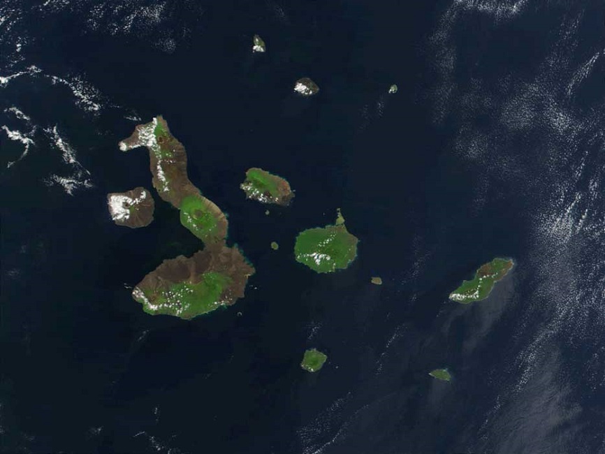


Refer to the “Galapagos Archipelago” chapter in Darwin's Voyage of the Beagle for the places where he went ashore.
| Placename | Modern Name | Latitude | Long. West |
View all place names  |
— | ||
| Hood Island —eastern summit | Española | A 1° 25' 00" S | 89° 43' 55" |
| Charles Island —summit | Santa María/Floreana | B 1° 19' 00" S | 90° 32' 00" |
| Charles Island —Post Office Bay—southeast corner | Santa María/Floreana | C 1° 15' 25" S | 90° 31' 30" |
| MacGower [sic, Macgowen] Rocks—middle | Macgowen Rocks | D 1° 08' 30" S | 89° 59' 30" |
| Albemarle Island —Iguana Cove—southwest extreme | Isabela | E 0° 59' 00" S | 91° 32' 15" |
| Chatham Island —Watering Cove beach | San Cristóbal | F 0° 56' 25" S | 89° 36' 25" |
| Barrington Island —summit at west end | Santa Fe | G 0° 50' 30" S | 90° 10' 00" |
| Chatham Island —southwest point of Stephens Bay | San Cristóbal | H 0° 50' 00" S | 89° 36' 45" |
| Chatham Island —eastern summit | San Cristóbal | I 0° 44' 15" S | 89° 20' 45" |
| Indefatigable Island —summit of islet in N.W. Bay—Eden Islet | Santa Cruz & Eden | J 0° 33' 25" S | 90° 37' 45" |
| Narborough Island —northwest extremity | Fernandina | K 0° 20' 00" S | 91° 44' 45" |
| Albemarle Island —Tagus Cove | Isabela | L 0° 15' 55" S | 91° 26' 45" |
| James Island —Sugar Loaf near west end | San Salvador/Santiago | M 0° 15' 20" S | 90° 56' 40" |
| James Island —cove on N.E. side § | San Salvador/Santiago | N 0° 10' 00" S | 90° 50' 00" |
| James Island —cove on N.E. side § {Porter's Adams Bay} | San Salvador/Santiago | N 0° 13' 22" S | 90° 36' 12" |
| James Island —Adam [sic, Buccaneer] Cove | San Salvador/Santiago | O 0° 10' 00" S | 90° 50' 00" |
| Bindloes Island —southernmost summit | Marchena | P 0° 18' 50" N | 90° 33' 55" |
| Towers Island —westernmost cliff | Genovesa | Q 0° 20' 00" N | 90° 02' 30" |
| Abingdon Island —summit | Pinta | R 0° 34' 25" N | 90° 48' 10" |
| Culpepper Islet —summit | Darwin | S 1° 22' 55" N | 91° 53' 30" |
| Wenman Islet —northwestern summit | Wolf | T 1° 39' 30" N | 92° 04' 30" |
§ Presumably, FitzRoy's “cove on N. E. side” is Adam Cove [actually named Adams Bay by David Porter].
FitzRoy duplicates Buccaneer Cove coordinates in error; corrected coordinates are included in above table.